


|
||

|

|
|

|
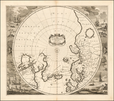
The late 17th century was a time of significant maritime exploration, and this spirit of discovery is embodied in the fascinating polar regions map published by this rare map by Johann Christoph Beer, published in Nuremberg. This soughtafter miniature map encapsulates the state of exploration in the late 17th Century in a concise outline form, referencing major milestones which reflect the geographical knowledge of the region to date.
Major Explorers and the Northwest Passage:
The Northwestern regions on the map highlight the tireless efforts of explorers seeking the elusive Northwest Passage. This sought-after water route connected the Atlantic and Pacific Oceans, offering the tantalizing possibility of shorter trade routes to Asia.
-
Button's Bay: Named after Sir Thomas Button, an English explorer who, in the early 17th century, explored and mapped parts of what is now Manitoba and Nunavut in Canada. His journey added considerably to the European knowledge of the region.
-
Baffin's Bay: This vast body of water is named after William Baffin, an English explorer who ventured further north than any previous explorer. His meticulous records, though initially dismissed, were later validated, solidifying his legacy.
-
Hudson's Bay and Hudson's Straits: Henry Hudson, an English explorer, while searching for the Northwest Passage, found himself trapped in the immense bay which now bears his name. Unfortunately, his crew mutinied, leaving him adrift in the very waters he had explored.
-
Davis Straits: Named after John Davis, an English explorer and navigator who made three attempts to find the Northwest Passage. His efforts opened up the Arctic seas for further exploration and whaling.
-
Frobisher's Strait: Sir Martin Frobisher, an English adventurer, believed he had discovered the Northwest Passage on his voyage to the Canadian Arctic. The strait named in his honor testifies to his zeal, even if his discovery was not the sought-after passage.
Iceland and Mt. Hecla:
While Iceland was already a known entity by the 17th century, Mt. Hecla, one of its most active volcanoes, was especially noteworthy. In the 17th century, Mt. Hecla had significant eruptions in 1636 and 1693, drawing European attention and likely influencing its inclusion in the map.
The Northeast Passage:
While the Northwest Passage garnered much attention, the Northeast Passage was also a region of interest:
-
Spigelberg: A misspelling or variant of "Spitsbergen," an island in the Svalbard archipelago, which served as a strategic point for Arctic exploration.
-
Nova Zemla: An Arctic archipelago in the north of Russia, it was a significant landmark for those attempting to navigate the Northeast Passage, which was first reached in the late 16th Century by Barentsz.
-
Weigatz: This refers to the Yugorsky Strait, an important passage between the Kara Sea and the Pechora Sea, essential for Arctic navigation.
Oceanus Septentrionalis et Glacialis:
Translating to "The Northern and Icy Ocean", this naming encapsulates the challenging and icy nature of the Arctic sea, a vast expanse that was both a barrier and an invitation for explorers.
![[ Polar Regions ] Pais qui Dependent de la Norvege Suivant les Derniers Relations Par N. de Fer.](https://storage.googleapis.com/raremaps/img/small/100688.jpg)
![[SAS -- Polar Airline Route]](https://storage.googleapis.com/raremaps/img/small/71578.jpg)
![[ Exceptional original hand-color with highlights in gold ] Typus Aspectuum Oppositionum Et Coniunctionum Etz In Planetis](https://storage.googleapis.com/raremaps/img/small/81866.jpg)