|
||

|

|
|

|
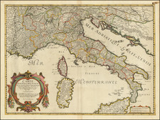
The map of Italy published by Herman Moll reflect the complexity of the Italian region's political divisions at the time.
The map provides a fascinating glimpse into the geopolitical state of Italy during the early 18th century. Moll's map of Italy is relatively small and straightforward, yet it captures a complex political landscape. It portrays the Italian peninsula, along with the surrounding seas and islands, such as Sicily and Sardinia. City names, rivers, mountains, and other geographical features are clearly marked. As noted in the title, the primary function of the map is the delineation of the various sovereignties that held control over different parts of Italy during that period.
The Kingdom of Naples encompassed the southern part of Italy. It was under Spanish rule until the War of the Spanish Succession (1701-1714), after which it fell under Austrian control before being reclaimed by the Spanish in 1735.
The Papal States, governed directly by the Pope, held sway over a substantial central portion of Italy. They represented a unique political entity in Europe, combining religious and temporal powers.
Located in the northwestern part of Italy, the Duchy of Savoy was an independent state that played a pivotal role in the politics of the region. By 1720, it also controlled the island of Sardinia.
The Venetian Republic controlled parts of northeastern Italy and was renowned for its naval power and trade.
Numerous smaller duchies and republics, such as Modena, Parma, and Genoa, contributed to the fragmented political landscape.
During the period first half of the 18th Century, Italy was a mosaic of sovereign states, each with its unique political alignment and interests. The War of the Spanish Succession led to a significant reshuffling of territories and powers. Treaties like the Treaty of Utrecht (1713) redrew boundaries, impacting control over regions like Naples and Sicily.
In the subsequent decades, alliances shifted, and borders were redrawn through various treaties and agreements. The balance of power was continually in flux, with different states jockeying for influence and control, until the process of unification under Garibaldi in the middle of the 19th Century.
Herman Moll (c. 1654-1732) was one of the most important London mapmakers in the first half of the eighteenth century. Moll was probably born in Bremen, Germany, around 1654. He moved to London to escape the Scanian Wars. His earliest work was as an engraver for Moses Pitt on the production of the English Atlas, a failed work which landed Pitt in debtor's prison. Moll also engraved for Sir Jonas Moore, Grenville Collins, John Adair, and the Seller & Price firm. He published his first original maps in the early 1680s and had set up his own shop by the 1690s.
Moll's work quickly helped him become a member of a group which congregated at Jonathan's Coffee House at Number 20 Exchange Alley, Cornhill, where speculators met to trade stock. Moll's circle included the scientist Robert Hooke, the archaeologist William Stuckley, the authors Jonathan Swift and Daniel Defoe, and the intellectually-gifted pirates William Dampier, Woodes Rogers and William Hacke. From these contacts, Moll gained a great deal of privileged information that was included in his maps.
Over the course of his career, he published dozens of geographies, atlases, and histories, not to mention numerous sheet maps. His most famous works are Atlas Geographus, a monthly magazine that ran from 1708 to 1717, and The World Described (1715-54). He also frequently made maps for books, including those of Dampier’s publications and Swift’s Gulliver’s Travels. Moll died in 1732. It is likely that his plates passed to another contemporary, Thomas Bowles, after this death.
![[Tuscany / Florence] Dominio Fiorentino](https://storage.googleapis.com/raremaps/img/small/89663.jpg)