|
||

|

|
|

|
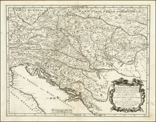
The Etats Orientaux De L'Empereur a partir De La Baviere Et De La Boheme is a detailed map crafted by Edme Mentelle and engraved by P.F. Tardieu in 1788, Paris. It was created for the work titled "De la Monarchie Prussienne." Mentelle served as the historiographer to the Count of Artois and was a well-regarded geographer of his time.
This map portrays Eastern Europe, from the region north of the Danube River up to southern Poland. It offers a focused look at the Habsburg Empire's eastern states, starting from Bavaria and Bohemia. During this period, the Empire was a complex and culturally diverse entity, stretching across a large part of Central and Eastern Europe.
In the late 18th century, maps such as this were of significant importance for understanding political territories, resources, and strategic advantages. The map reflects the political geography of Eastern Europe at the time, marked by the complex territorial claims and boundaries of various empires.
![[Nové Zámky/Érsekújvár] Abris der Festung Neuheusel Wie solche von Kay May: Armada underm General Bocquoy Belagert gewesen](https://storage.googleapis.com/raremaps/img/small/75327.jpg)
![[ Siege of Pilsen ] Abriss der Statt Pilsen in Böhmen... Eingenohmen worden (Demolition of the town of Pilsen in Bohemia . . . )](https://storage.googleapis.com/raremaps/img/small/99305.jpg)
![(Czech Republic) Chorographia insignis regni Bohemiae [Remarkable Chorography of the Kingdom of Bohemia.]](https://storage.googleapis.com/raremaps/img/small/75283.jpg)