


|
||

|

|
|

|
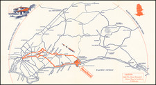
Rare blue line map of the Point Loma Electric Railway, issued shortly after the railway's creation in the early 20th Century.
Extending here from Old Town to Point Loma Heights and and Ocean Beach, the line herald's the growth of the new beach community.
In the early 20th century, the burgeoning coastal communities of Point Loma and Ocean Beachunderwent a transformational shift. The Point Loma Electric Railway, which would later evolve into the Point Loma Railroad Co. (PLRR), stood at the heart of this change, reshaping the transportation and socio-economic landscape of the region.
In 1909, under the visionary leadership of Col. D.C. Collier, the Point Loma Electric Railway started a revolution in regional connectivity. On May 1, 1909, a seminal moment in San Diego's transportation history, the railway commenced operations, heralding a new era for Ocean Beach (OB). For the first time, people could comfortably work in downtown San Diego and live alongside the pristine waters of the Pacific Ocean, a proposition that was previously untenable. This transformative railway made the dream of an oceanside lifestyle accessible to many, turning OB into a thriving community.
Ocean Beach had first been laid out in 1887, but following the boom times of the late 1880s, the area was largely abandoned. During the real estate bust of the 1890s, many buyers lost their lots and development stagnated except for a few houses used for vacation getaways. One of those who stayed with the community Collier who began promoting Ocean Beach and Point Loma. In the first decade of the 1900s, he brought in electricity, some paved streets, and a street car line.
The franchise for the Point Loma Electric Railway sketched out an ambitious route. It was set to extend from the terminus of the San Diego Electric Railway’s State Street Line, charting a path between Kurtz and Hancock streets. It would cross the Santa Fe tracks at Witherby Street and venture out via Tide Street (now known as Barnett Avenue), heading towards Lytton and Rosecrans streets. This comprehensive network was designed to knit together the urban core with the coastal fringes, fostering greater mobility and economic growth.
The blueprint for the Point Loma Electric Railway soon expanded beyond its original scope. Within its inaugural year, the scale and vision for the railway grew exponentially. This evolution led to the rebranding and restructuring of the railway into the Point Loma Railroad Co., a more robust and better-capitalized entity. It's worth noting that PLRR was fiercely independent. Its goals, plans, and the substantial financial commitments it made in materials and labor were autonomous, reflecting a bold and singular vision for the future of Point Loma and Ocean Beach.
Blueprint & Blue Line maps (Cyanotype Printing)
Blueprint and blue line maps were among the most popular means for the swift printing of maps for which there would be a limited demand. A blueprint or blue line map could be made and/or revised much more quickly than a lithograph, cerograph, or other printing method, and at a much lower cost.
This method of printing was invented in 1842 by John Herschel, a chemist, astronomer, and photographer. A cyanotype process, one starts by drawing on semi-transparent paper, weighted down by a top sheet of paper. The paper would be coated with a photosensitive chemical mixture of potassium ferricyanogen and ferric ammonium citrate. The paper would then be exposed to light, wherein the exposed portions turned blue and the drawn lines, protected from exposure, would remain white.
The cyanotype printing process was an improvement on the expensive and time-consuming method of hand-tracing original documents. The technique was particularly popular with architects; by the 1890s, a blueprint was one-tenth the cost of a hand-traced reproduction. It could also be copied more quickly.
Blueprint and blue line maps began to appear as early as the 1850s and 1860s, but they really began to become the standard for mining and similar limited-purpose maps by the 1880s. The ability to create these maps quickly and at a low cost made them the standard for short-run prints, ideal for mapping mining regions in the West and for similar purposes.
The method still exists today, but in a very limited fashion. In the 1940s, diazo prints (whiteprints or bluelines) became more popular, as they were easier to read and faster to make. The blue lines on a white background of these prints are now what most people call blueprints.
![[ Petco Park / San Diego Downtown Ballpark Proposal - 89 June 1999 ]](https://storage.googleapis.com/raremaps/img/small/105522.jpg)
![(San Diego) Map of the Water Front of San Diego on San Diego Bay Showing the Line of Mean High Tide [National City to Old Town] [with] Map of the Water Front of San Diego on San Diego Bay Showing the Line of Mean High Tide [Midway District to Point Loma]](https://storage.googleapis.com/raremaps/img/small/95403.jpg)
![(San Diego) [Set of sixteen early aerial photographs of San Diego]](https://storage.googleapis.com/raremaps/img/small/95394.jpg)