|
||

|

|
|

|
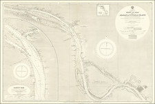
Map to illustrate Notes on Routes from Bushire to Shiraz, By Lt Genl. Monteith; and from Shiraz to Dáráb & thence to Kazerún, By Consul Keith E. Abbott, 1850 is an informative geographical document prepared by John Arrowsmith and published in London in 1857. Created to accompany the writings of Lieutenant General Monteith and Consul Keith E. Abbott, the map traces the routes from Bushire to Shiraz and from Shiraz to Dáráb and Kazerún, with distinct coloration for each author's routes, and includes an inset of the continuation from Bunder Dellim to Shuster.
The 1850s was a time of increased British interest and influence in Persia, particularly in the regions depicted in this map. The routes charted by Lt Genl. Monteith and Consul Abbott, two prominent British figures in the region, offer valuable insights into the geographical knowledge and exploration of the time. General Monteith was heavily involved in surveying and mapping activities, while Consul Abbott was a key diplomatic figure in the British legation.
This map is significant in the context of British-Persian relations, as it represents a period where accurate geographical information was crucial for political, military, and commercial purposes. The color-coding of the routes, specifying those charted by Monteith in red and Abbott in blue, allows for a nuanced understanding of the different explorations and perspectives.
Furthermore, the inclusion of the inset detailing the continuation from Bunder Dellim to Shuster adds depth to the geographical portrayal of the region. The detail and comprehensive coverage make this a valuable resource for scholars studying the historical geography and British involvement in Persia during the mid-19th century.
Published for the Journal of the Royal Geographical Society by John Murray, a prominent British publishing house, this map reflects the scholarly and exploratory ethos of the time. John Arrowsmith's expertise in cartography adds further credibility to this document. It stands not only as an artifact of geographical exploration but also as a symbol of the era's international dynamics and the intricate relationship between knowledge and power.
The Arrowsmiths were a cartographic dynasty which operated from the late-eighteenth century to the mid-nineteenth. The family business was founded by Aaron Arrowsmith (1750-1823), who was renowned for carefully prepared and meticulously updated maps, globes, and charts. He created many maps that covered multiple sheets and which were massive in total size. His spare yet exacting style was recognized around the world and mapmakers from other countries, especially the young country of the United States, sought his maps and charts as exemplars for their own work.
Aaron Arrowsmith was born in County Durham in 1750. He came to London for work around 1770, where he found employment as a surveyor for the city’s mapmakers. By 1790, he had set up his own shop which specialized in general charts. Arrowsmith had five premises in his career, most of which were located on or near Soho Square, a neighborhood the led him to rub shoulders with the likes of Joseph Banks, the naturalist, and Matthew Flinders, the hydrographer.
Through his business ties and employment at the Hydrographic Office, Arrowsmith made other important relationships with Alexander Dalrymple, the Hudson’s Bay Company, and others entities. In 1810 he became Hydrographer to the Prince of Wales and, in 1820, Hydrographer to the King.
Aaron Arrowsmith died in 1823, whereby the business and title of Hydrographer to the King passed to his sons, Aaron and Samuel, and, later, his nephew, John. Aaron Jr. (1802-1854) was a founder member of the Royal Geographical Society (RGS) and left the family business in 1832; instead, he enrolled at Oxford to study to become a minister. Samuel (1805-1839) joined Aaron as a partner in the business and they traded together until Aaron left for the ministry. Samuel died at age 34 in 1839; his brother presided over his funeral. The remaining stock and copper plates were bought at auction by John Arrowsmith, their cousin.
John (1790-1873) operated his own independent business after his uncle, Aaron Arrowsmith Sr., died. After 1839, John moved into the Soho premises of his uncle and cousins. John enjoyed considerable recognition in the geography and exploration community. Like Aaron Jr., John was a founder member of the RGS and would serve as its unofficial cartographer for 43 years. Several geographical features in Australia and Canada are named after him. He carried the title Hydrographer to Queen Victoria. He died in 1873 and the majority of his stock was eventually bought by Edward Stanford, who co-founded Stanford’s map shop, which is still open in Covent Garden, London today.
![Turquie d'Asie, Arabie, Perse, Caboul, Beloutchistan et Turkestan [Asia Minor, Arabia, Persia, Kabul, Baluchistan and Turkestan]](https://storage.googleapis.com/raremaps/img/small/94469.jpg)