|
||

|

|
|

|
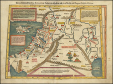
This map is a finely engraved, mid-17th-century cartographic depiction of the Holy Land, meticulously engraved by Jacob Savry III (1617-1666).
The map's orientation, with the east at the top, deviates from the traditional north-oriented maps, demonstrating an understanding of the region from a perspective that aligns with Biblical narratives. It includes the Eastern Mediterranean's coastal waters and significantly illustrates part of Paul's travels as he lands at Sidon and Cesarien.
From the coastal city of Tripolis in the "Landt der Gibeliten," the map extends southwards to the city of Gaza, representing the territories of the Ismaelites along the way. Eastwards, it spans to Damascus, across 'T land't Aram Hus, Bostra, Nabatha, and Rabbat Moab, and stretches further to the territories of Dibon Gad, Steen Achtich, Woeste Arabia, Arabia Petrea, and Petra, by the northern end of the Dead Sea. These geographies reflect significant biblical narratives and the historical context of the time.
Adding an artistic flourish to its historical relevance, the map also incorporates a scene of Christ's crucifixion on a hilltop at the top left. This intricate representation, surrounded by soldiers and followers in elaborate costumes, provides an immersive visual experience. The Biblical references to Matthew 27:35, Marc 15:25, Luce 23:33, and Ioan 19:18 offer context and depth, revealing the map's intention to serve as a spiritual guide as well as a geographical representation.
Emphasizing its religious symbolism, a decorative cartouche embellishes the map. It includes a cross, the tablets of the 10 commandments, the New Testament, and construction tools, all guarded by two cherubs. This choice of embellishment further underlines the map's religious undertones, signifying the covenant between God and humanity.
In terms of physical geography, the map is skillfully designed to emphasize the mountains, rivers, lakes, and rugged terrain of the region. These elements, highlighted with an artistic sense of realism and detail, give viewers an insight into the challenging landscapes that would have been navigated in biblical times.
The title of the map, "Geographische beschryvinge van t'Beloofde-Landt Canaan, door wandelt van onsen Heere ende Salichmaecker Iesu Christo nessens Syne Apostelen van nieus gecorigeert ende seer verbetert," is in Dutch. Translated into English, it means "Geographical description of the Promised Land of Canaan, traversed by our Lord and Savior Jesus Christ and his Apostles, newly corrected and greatly improved."
As for the Dutch terms within the map, they translate as follows:
- "Tripolis t'Landt der Gibeliten": The city of Tripoli, the Land of the Giblites.
- "Ismaeliten landt en Wooninge": The land and dwelling of the Ismaelites.
- "'T land't Aram Hus": The land of Aram Naharaim.
- "Bostra, Nabatha": Bostra, Nabataea.
- "Ar. ofte Rabbat Moab de hoost Stadt Moabs": Rabbath Moab, the chief city of Moab.
- "Dibon Gad": Dibon Gad, a town east of the Jordan River.
- "Steen Achtich ofte Woeste Arabia": Stony or Desert Arabia.
- "Arabia Petrea": Rocky Arabia.
- "Petra": Petra, the capital city of the Nabataeans.
![Arabia, Petraea et Deserta [Saudi Arabia, etc.]](https://storage.googleapis.com/raremaps/img/small/87833.jpg)
![Syrie Ancienne [shows Cyprus]](https://storage.googleapis.com/raremaps/img/small/89269.jpg)