|
||

|

|
|

|
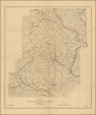
The 1922 map of Colville National Forest, produced by the US Forestry Service, stands as a testament to the government's effort to consolidate, manage and conserve the natural resources of the nation. The map, originally compiled in 1917 by the District Office in Portland, was traced by D.H. Blakelock and R.H. Robinson. Later, in March 1922, E.R. Knox improved and revised it, adding further depth to its already meticulous detailing.
The map outlines the boundaries of the national forest and indicates an area known as the "state land exchange area" established under a proclamation dated November 4, 1921. This proclamation was a pivotal legislative act of its time, primarily concerning land management and reclamation. It allowed for an exchange of state and privately held lands within the boundaries of national forests for federally owned forested lands outside these boundaries. The proclamation's aim was twofold: it consolidated national forest landholdings, making management easier, and it also redistributed lands to state and private ownership, promoting sustainable use and economic development.
A comprehensive legend accompanies the map, with various symbols denoting key landmarks and features. These include Ranger Stations, triangulation stations used for surveying, lookout and triangulation stations, railroads, primary and secondary roads, first and second class trails, mines, springs, falls, dams, and the forest supervisor's headquarters. Such details not only added to the map's utility but also provided a snapshot of the development and use of the land at that time.
The 1922 map of Colville National Forest, meticulously traced and revised by the U.S. Forestry Service, encapsulates more than mere geography. It offers a unique window into the unfolding narratives of exploration, exploitation, conservation, and transformation that marked the history of this forest from the 19th to the early 20th century.
The landscape represented on the map began changing considerably with the arrival of the first non-Indian, David Thompson, in 1809. A fur trapper from Canada, Thompson's presence heralded an influx of trappers lured by the rich abundance of beaver, marten, and other animals. Their interactions with the indigenous tribes introduced new elements into tribal culture, including beads, tools, and alcohol.
By 1826, American fur traders established Fort Colville near Kettle Falls. These newcomers brought in livestock, started farming around the fort, and restricted native access to essential fishing grounds. By the late 19th century, indigenous tribes were confined to reservations, and the construction of the Grand Coulee Dam in the 1930s submerged Kettle Falls and its critical salmon runs under Roosevelt Reservoir.
The turn of the 20th century saw miners and homesteaders flocking to Colville, drawn by tales of wealth in its mountains and valleys. However, they met with little success. Gold and silver found around the Republic area were not as plentiful elsewhere, and the short growing season deterred farming. The population in northeast Washington declined significantly; by 1920, it was half of what it had been in 1910. Remnants of these futile endeavors are visible today in the form of abandoned mines and decaying cabins scattered throughout Colville National Forest.
However, loggers and ranchers found the landscape much more accommodating. They capitalized on the ample trees and grasslands, using the public land extensively. Initially, land use was unregulated, leading to environmental degradation. The establishment of Colville National Forest in 1906, however, marked a turning point. Forest rangers began overseeing resource harvests, curbing the rampant exploitation of resources. Despite initial friction, a workable relationship eventually evolved between the Forest Service and those utilizing the national forest lands..
The area encompassing the Colville National Forest has a rich history dating back to the mid-19th century. The Colville Indian Reservation was established in the region in 1872, following a series of treaties and executive orders. Over the next decades, waves of settlers, miners, and loggers transformed the landscape. Railroads were constructed, mines dug, roads paved, and trails blazed.
In the early 20th century, the creation of the National Forest heralded a new era of conservation. The impact of this shift is evident on the 1922 map, where previously uncontrolled industries like mining and logging now appear within a systematic network of trails, roads, and ranger stations. Simultaneously, the map shows a landscape still being actively used and developed, with markers for railroads, mines, dams, and springs.
In conclusion, the 1922 map of Colville National Forest offers far more than geographical knowledge. It represents an intersection of history, policy, and nature. The map encapsulates the transformation of an area under the US Forest Service's stewardship, showing how an unregulated frontier was molded into a sustainably used, protected natural resource. Furthermore, it gives us a unique insight into early 20th century American attitudes toward conservation, land use, and development.
![(Canadian-American Boundary) [Group of 11 photographs by Alexander Gardner, including 3 after the British Commission's 1860-61 photographs, for the North American Boundary Commission Survey along the 49th Parallel, used in settling Hudson's Bay Co. claims in the British and American Joint Commission]](https://storage.googleapis.com/raremaps/img/small/95481.jpg)