


|
||

|

|
|

|
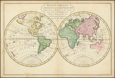
The circa 1790 English map of the world provides a concise illustration of Captain James Cook's three significant voyages, which began in 1768. This double hemisphere map, with an inset map of the north polar regions at the bottom center, is an informative representation of exploration during a vital era of geographic discovery.
Captain Cook's first voyage, launched in 1768, aimed to observe the transit of Venus but extended to charting the South Pacific islands and the circumnavigation of New Zealand. The map accurately delineates these routes, outlining his path through Tahiti and other islands.
The second voyage, commencing in 1772, focused on the exploration of the southern hemisphere, particularly the Antarctic region. Cook's sighting of "field ice" in 1773 and 1774, as noted on the map, provided valuable insights into the geography of these icy regions.
Cook's third and final voyage, beginning in 1776, sought to find a navigable route through the North-West passage. This exploration led him to the Northwest Coast of America and the Hawaiian Islands, where he met his end in 1779. The map's depiction of these paths captures his ambitious attempts to explore these uncharted areas.
In addition to the main hemispheres, the inset map at the bottom center focuses on the northern polar regions, highlighting Cook's efforts in exploring these challenging territories.
In summary, this circa 1790 English map offers a straightforward depiction of Captain James Cook's explorations. More than a historical artifact, the map serves as a clear record of Cook's significant contributions to geographic knowledge. His explorations of the Pacific, Australia, and the Antarctic region, as shown on the map, helped reshape the world's understanding of these areas at that time.

![Pour Les Vents [world map centered on Asia]](https://storage.googleapis.com/raremaps/img/small/59768.jpg)