|
||

|

|
|

|
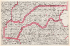
Stock# 96284
Description
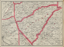
Early Regional Map of California
Scarce regional map of Alpine, Amador, Calaveras, El Dorado, Placer, Sacramento, San Joaquin, Sutter, Tuolumne and part of Colusa, Contra Costa, Mono, Nevada, Solano, Stanislas, Yolo and Yuba Counties.
Many small towns, railroads, rivers, mountains, Indian villages, railway stations, mines, and other details are shown.
One of the few detailed separate maps of the region to appear in a 19th Century Commercial Atlas.
![[ Lake County Rancho ] Map of the Guenoc County Rancho Finally Confirmed To A.A. Ritchie & P.S. Forbes, Surveyed under the Direction of the U.S. Surveyor General By Wm. Denton Deputy Surveyor. June 1857.](https://storage.googleapis.com/raremaps/img/small/102630.jpg)