|
||

|

|
|

|
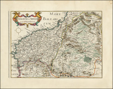
The mid-20th-century topographical map of Huesca/Northern Aragon region, prepared by the Dirección General del Instituto Geográfico y Catastral, is an impressive depiction of this part of Spain. The map provides a comprehensive representation of the region's natural and human-made landscapes.
The region's unique topographical features are presented with meticulous detail, reflecting the cartographers' skills and the accuracy of the mapping technologies available at the time. Rivers, streams, and other water bodies are carefully marked, signifying their importance in the region's ecological and hydrological systems.
An aspect worth noting about this map is its use of symbols and color. Different colors are used to distinguish between various land uses and cover types, such as forests, agricultural fields, and urban areas. A detailed legend assists users in interpreting these symbols and colors, adding to the map's usability.
The Dirección General del Instituto Geográfico y Catastral, or the General Directorate of the Geographic and Cadastral Institute, has been a cornerstone in Spanish geography and cartography since its inception in the 19th century.
Established by a Royal Decree on September 12, 1870, the Geographical Institute was initially part of the General Directorate of Statistics within the Ministry of Public Works. This formation integrated the collection of numerical information under the umbrella of statistics.
However, during the First Republic in 1873, the General Directorate of Statistics was abolished. In its place, the General Directorate of the Geographical and Statistical Institute was formed, still under the Ministry of Public Works. The organization's responsibilities grew over the years, assuming control of the Weights and Measures Service in 1878 and the Madrid Astronomical and Meteorological Observatory in 1904.
Further significant evolution occurred in 1925 when it incorporated the rustic cadastre from the Ministry of Finance, leading to a change in its name to the General Directorate of the Geographical and Cadastral Institute. This change marked the birth of the Geographical, Cadastral, and Statistical Institute.
In 1935, the Institute underwent another transformation, ceasing to be a General Directorate and being recategorized as a national center of a scientific and cultural nature under the Ministry of Public Instruction and Fine Arts. This move acknowledged its educational significance.
During the Spanish Civil War, different organizational arrangements were made, such as the creation of the Union Statistics Service. Finally, in 1939, the Law of August 8 formed the General Directorate of the Geographic and Cadastral Institute within the Presidency of the Government. Further reorganization happened in 1946 with the establishment of the National Institute of Statistics.
Over the decades, the Institute has adapted and expanded its roles, proving its enduring importance in Spain's geographical and statistical landscape.

![Neuester und exacter Plan und Prospect von der Stadt Vestung Bay und Fortification Von Gibraltar…1733 [with view of Cadiz]](https://storage.googleapis.com/raremaps/img/small/91413.jpg)