|
||

|

|
|

|
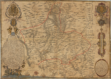
Detailed map of the region, which elegantly captures the essence of the western Spanish province during a dynamic era in the country's history. Nestled within the autonomous community of Extremadura, Cáceres province boasts a rich tapestry of history, culture, and geography that has been meticulously depicted in this map.
Created during Spain's transition from the dictatorial Franco era to a democratic governance, the map is not just a geographical representation, but also a reflection of the changing socio-political climate. It captures the intricacies of the province's landscapes, settlements, and administrative divisions with a level of detail that speaks volumes about the advancements in cartographic techniques prevalent in the late 1960s.
The map's depiction of the provincial capital, Cáceres city, is remarkably precise, capturing the layout of this UNESCO World Heritage site with its well-preserved medieval city walls, and its blend of Roman, Moorish, Gothic and Italian Renaissance architecture. The map also meticulously plots smaller towns and villages such as Plasencia, Coria, and Trujillo, each with their unique historical and cultural significance.
Cáceres' diverse natural landscape is another feature captured in the map. It artfully illustrates the topographical variations ranging from the rugged Sierra de Gata mountain range in the north to the expansive plains of the Tierra de Barros to the south. The depiction of the Monfragüe National Park, a famed area known for its Mediterranean forests and a variety of wildlife, adds another layer of ecological importance to the map.
Key infrastructure like roads, bridges, and railway lines are traced out with precision, representing the transport links that connect the remote corners of the province. The presence of these structures signals the economic activities and developmental strides taken during that period.
One of the map's significant historical insights is the demarcation of Roman roads and ancient trade routes, hinting at the region's historic importance as a crossroads of civilizations. This aspect connects the contemporary landscape back to its roots, providing a glimpse into the region's vibrant past.
![[Gipuzkoa / Bay of Cadiz / Toledo - Tagus River ] Hanc Insulam Perlustrabat . . . [with] Carpetaniae . . . 1584 [with] Guipuscoae Regionis Typus. . .](https://storage.googleapis.com/raremaps/img/small/78971.jpg)