|
||

|

|
|

|
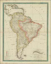
Detailed map of South America, engraved by de la Haye.
One of the most detailed maps of South America to appear in a commercial atlas in the mid-18th Century, published by the leading French map maker of the period.
The map provides an excellent look at colonial South America. The map largely benefits from the results of the epic Spanish-French Equatorial Geodesic mission (1735-44). This endeavor was part of an effort to solve one of the most vexing questions of early Enlightenment science: whether the shape of the earth was oblate (flattened at the poles) or prolate (flattened near at the Equator). One of the critical factors in resolving the matter was measuring a length of a meridian arc of latitude at the Equator. The related Franco-Swedish Geodesic Expedition, which travelled to Lapland in 1736, proved that the earth's shape was oblate.
The mission was led by the French astronomers Charles Marie de La Condamine, Pierre Bouguer, Louis Godin and the Spanish geographers Jorge Juan y Santacilia and Antonio de Ulloa. The mission was groundbreaking as it was the first truly international scientific mission, idealistically placing scientific inquiry above parochial nationalism.
The mission's great cartographic achievement was to measure the arc of the meridian over three degrees of latitude, from the Equator to 3 degrees south. This resulted in the heart of Ecuador, the corridor from Quito to Cuenca, being mapped to exacting scientific standards by means of triangulated surveys. This ensured that the corridor was then one of the most accurately mapped areas in all of the Americas.
Jean-Baptiste Bourguignon d’Anville (1697-1782) was one of the foremost French geographers of the eighteenth century. He carried out rigorous research in order to create his maps, which greatly developed the technical proficiency of mapmaking during his lifetime. His style was also simpler and less ornate than that of many of his predecessors. It was widely adopted by his contemporaries and successors.
The son of a tailor, d’Anville showed cartographic prowess from a young age; his first map, of Ancient Greece, was published when he was only fifteen years old. By twenty-two, he was appointed as one of the King’s géographes ordinaire de roi. He tutored the young Louis XV while in the service to the Crown. However, royal appointment did not pay all the bills, so d’Anville also did some work for the Portuguese Crown from 1724. For example, he helped to fill out Dom João V’s library with geographical works and made maps showing Portugal’s African colonies.
D’Anville disapproved of merely copying features from other maps, preferring instead to return to the texts upon which those maps were based to make his own depictions. This led him to embrace blank spaces for unknown areas and to reject names which were not supported by other sources. He also amassed a large personal map library and created a network of sources that included Jesuits in China and savants in Brazil. D’Anville’s historical approach to cartography resulted in magnificently detailed, yet modern and academic, maps. For example, his 1743 map of Italy improved upon all previous maps and included a memoir laying out his research and innovations. The geographer also specialized in ancient historical geography.
In 1773, d’Anville was named premier géographe de roi. In 1780, he ceded his considerable library to the Ministry of Foreign Affairs to be used for as a reference library for diplomats. D’Anville is best known for several maps, including his map of China, first published in 1735, and then included with Du Halde’s history of that country (the Hague, 1737). His map of Africa (1749) was used well into the nineteenth century.
![[ World & Continents ] Typus Orbis Terrarum / Americae Sive Novi Orbis Nova Descriptio / Asiae Nova Descriptio / Africae Tabula Nova / Europae](https://storage.googleapis.com/raremaps/img/small/99250.jpg)