


|
||

|

|
|

|
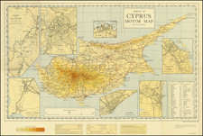
This A-Z Street Map of Limassol & Suburbs, published around 1990 by the Cyprus Popular Bank, provides a comprehensive guide to the city and its surrounding areas. Limassol is the second largest urban area in Cyprus, renowned for its vibrant culture, historical landmarks, and picturesque Mediterranean coastline.
This street map details a variety of features including residential and commercial areas, parks, and main points of interest. Noteworthy landmarks such as churches (Ch.), cinemas (Cin.), schools (Sch.), gymnasiums (Gym.), and government offices (G.O.) are specifically marked, making navigation through the city and suburbs easy for both residents and tourists.
Though outdated by modern standards, this map gives an interesting glimpse into the urban layout and cultural hotspots of Limassol during the late 20th century. Its publication by the Cyprus Popular Bank also indicates the bank's role in community affairs and local tourism during this time.
Date very roughly estimated.
![[ Holy Land & Cyprus ] Soria Et Terra Santa Nuova Tavola](https://storage.googleapis.com/raremaps/img/small/88442.jpg)
![Tab. IV. Asiae in qua Mesopotamia, Syria, Arabia Petrea ac Deserta . . . [Shows Cyprus]](https://storage.googleapis.com/raremaps/img/small/97732.jpg)
![[Cyprus, Holy Land, Syria Middle East] Tabula Asiae IIII](https://storage.googleapis.com/raremaps/img/small/84169.jpg)