|
||

|

|
|

|
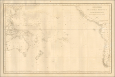
World War II-era chart in 1:3,000,000 scale of the southwestern Pacific, showing New Caledonia, the North Island of New Zealand, Norfolk Island, the Loyalty Islands, Aneityum, Tonga, and Buffon Reef. Many of these ports served as naval bases or refueling stops. The verso has eight maps detailing the Auckland area (with Devonport), Noumea area (including the Central Camp at Nouville and East Convict Camp), Napier area, Raoul Island, Norfolk Island, Philip Island, Macauley Island, and Curtis Island.
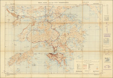
AtoNs (Aids to Navigation such as lighthouses, buoys, and beacons) have their lighting abbreviation— flashing (Fl.), group flashing (Gp. Fl.), red flashing (Fl. R.), flashing white and red (Fl. W R), occulting (Occ.), group occulting (Gp. Occ.), and fixed or steady (F)— and location marked with a blue dot.