|
||

|

|
|

|
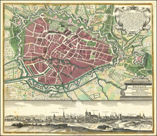
Nitidissimae Civitatis Mechlineensis In Meditullio Brabantiae Sitae Exactis: Delineatio, engraved and published in Cologne in 1581 by the renowned duo Braun & Hogenberg, presents a faithful view of the illustrious town of Mechelen, situated at the heart of Brabant. As a historical city, Mechelen witnessed significant events and shifts in power, most notably when Charles the Bold transferred the Supreme Court to the locale in 1473. This remarkable map offers insights into the urban landscape and the architectural essence of Mechelen in the late 16th century.
The late medieval period was a time of profound transformation for Mechelen. Initially acquiring prominence through staple rights and the cloth trade, Mechelen burgeoned into a celebrated center of commerce. The city's architectural landscape, dominated by structures such as the towering Sint-Rombout cathedral, which stands at an impressive height of nearly 100 meters, and the Onze-Lieve-Vrouwe church constructed in the Brabantine late Gothic style, testify to its rich historical and cultural lineage. The bird's-eye view, with its portrayal from the northwest, illuminates the near-circular formation of the inner city, showing the expansion beyond the canal delineating the ancient city walls.
Franz Hogenberg's connection to Mechelen, noted as his birthplace, is immortalized in the precise detailing of the city's topography. The presence of significant buildings and establishments gives viewers insights into the evolving urban fabric of Mechelen. The subsequent Habsburg rule, beginning in 1477, witnessed the city's rise as the capital of the Habsburg Netherlands from 1507 to 1530 under the regency of Margaret of Austria. The transition of Mechelen into an archbishopric in 1559 and its pivotal role during the Wars of Religion as a nucleus of the Counter-Reformation further solidified its historical significance.
The map is a testament to Mechelen's multifaceted history – from its economic rise through trade to its political and religious prominence within the Habsburg Netherlands. The documentation of this city, its streets, and its edifices provide invaluable insights into the socio-economic and political milieu of the late 16th century.
Georg Braun (1541-1622) was born and died in Cologne. His primary vocation was as Catholic cleric; he spent thirty-seven years as canon and dean at the church St. Maria ad Gradus, in Cologne. Braun was the chief editor of the Civitates orbis terrarum, the greatest book of town views ever published. His job entailed hiring artists, acquiring source material for the maps and views, and writing the text. In this role, he was assisted by Abraham Ortelius. Braun lived into his 80s, and he was the only member of the original team to witness the publication of the sixth volume in 1617.
Frans Hogenberg (ca. 1540-ca. 1590) was a Flemish and German engraver and mapmaker who also painted. He was born in Mechelen, south of Antwerp, the son of wood engraver and etcher Nicolas Hogenberg. Together with his father, brother (Remigius), uncle, and cousins, Frans was one member of a prominent artistic family in the Netherlands.
During the 1550s, Frans worked in Antwerp with the famous mapmaker Abraham Ortelius. There, he engraved the maps for Ortelius’ groundbreaking first atlas, published in Antwerp in 1570, along with Johannes van Deotecum and Ambrosius and Ferdinand Arsenius. It is suspected he engraved the title page as well. Later, Ortelius supported Hogenberg with information for a different project, the Civitates orbis terrarium (edited by Georg Braun, engraved by Hogenberg, published in six volumes, Cologne, 1572-1617). Hogenberg engraved the majority of the work’s 546 prospects and views.
It is possible that Frans spent some time in England while fleeing from religious persecution, but he was living and working in Cologne by 1580. That is the city where he died around 1590. In addition to his maps, he is known for his historical allegories and portraits. His brother, Remigius, also went on to some fame as an engraver, and he died around the same time as his brother.
![[ Roman Gaul ] Gallia Antiqua ex Aevi Romani Monumentis Eruta Et Sermi. Carnutum Ducis Munifentia Publici Juris Facta Acutor D'Anville . . . MDCCLX](https://storage.googleapis.com/raremaps/img/small/103405.jpg)