


|
||

|

|
|

|
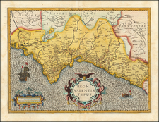
A Map of Old & New Castile From the Observations of Rodrigo Mendes Silva and others, published by John Senex in London in 1714, provides an intricate and detailed cartographic representation of the Spanish regions of Old Castile and New Castile, including the Kingdom of Leon, Estremadura, La Mancha, and others. This highly detailed map encompasses a wide array of geographical elements such as towns, roads, rivers, castles, lakes, and mountains.
The early 18th century was a time of political transition and territorial realignment in Europe. In Spain, the War of the Spanish Succession (1701–1714) had significant implications for the national and regional governance of the country. The map's publication coincides with the end of this war, and its focus on the historically significant regions of Old and New Castile highlights areas that were crucial to the political and economic life of Spain.
The inclusion of observations by Rodrigo Mendes Silva contributes to the map's value as a historical document. Silva's work, combined with other sources, offers a multifaceted perspective on the geography of the region. The extensive detailing of natural features, human-made structures, and transportation routes reflects the intricate understanding and importance of regional geography in the period.
John Senex, a renowned British cartographer and engraver, was noted for his precision and craftsmanship. This map's preservation, along with the absence of folds and the minor presence of non-archival tape, underscores the quality of its construction and its enduring significance.
Overall, A Map of Old & New Castile stands as a vital artifact of its time, encapsulating the geographical intricacies of a key region in Spain during a significant historical period. Its melding of meticulous detail, historical context, and careful preservation offers a window into the landscapes, political divisions, and cartographic practices of early 18th-century Europe.
John Senex (1678-1740) was one of the foremost mapmakers in England in the early eighteenth century. He was also a surveyor, globemaker, and geographer. As a young man, he was apprenticed to Robert Clavell, a bookseller. He worked with several mapmakers over the course of his career, including Jeremiah Seller and Charles Price. In 1728, Senex was elected as a Fellow of the Royal Society, a rarity for mapmakers. The Fellowship reflects his career-long association as engraver to the Society and publisher of maps by Edmund Halley, among other luminaries. He is best known for his English Atlas (1714), which remained in print until the 1760s. After his death in 1740 his widow, Mary, carried on the business until 1755. Thereafter, his stock was acquired by William Herbert and Robert Sayer (maps) and James Ferguson (globes).
![[Catalan Portolan Sea Chart] Descripcion de la Costa de España Portugal y Parte de la Barbaria contiene la sonda con la calidad de Fondo segun se a Podida y moestiear Advartencia . . . Sacado de su original en la Havana 1776](https://storage.googleapis.com/raremaps/img/small/50534.jpg)
![[Portugal / Morocco / Azores & Canary Islands] Pascaarte Van Barbarische cust mitsgaders van de Canarische en Vlaemsche Eijlanden](https://storage.googleapis.com/raremaps/img/small/75279.jpg)