|
||

|

|
|

|
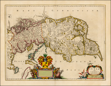
Finely crafted map of Southern Sweden and the Copenhagen area, published by J.B. Homann, the most prolific cartographic firm in the Holy Roman Empire during the first half of the 18th Century.
The geographic scope of the map reaches from key urban centers in the south like Malmo, Copenhagen, Lund, and Helsingborg. Moving northward, the map stretches to Kalmar, Falkenberg, and Varberg. Beyond the main map, an inset located in the top right corner details "Hallandia Septentrionale," further extending to the city of Gothenburg, just beyond the northern border of Hallandia.
The coastal regions are particularly captivating. Rugged coastlines, peppered with islands, present a vision of Scandinavia's unique maritime landscape. Moving inland, the intricate network of lakes and rivers is displayed with precision, revealing the waterways that have historically been vital for trade, transport, and agriculture. In the far north, the dense forests of southern Smalandia offer a glimpse of the verdant wilderness that dominates much of Sweden's northern hinterland.
Central to the map's aesthetics is the elaborate title cartouche, with Mermen depicted fishing with spears, a possible allegory for man's harnessing of the seas or the bounty and challenges that the ocean presents. Above the title, cherubs hold the coats of arms of Hallandia, Scania, and Blekinga, three significant provinces in the map's scope.
Brief Historical Overview
Scania (Skåne): Historically a part of Denmark, the 17th century saw intense battles between Sweden and Denmark for control over this region. By the Treaty of Roskilde in 1658, Denmark ceded Scania to Sweden. The Swedish Crown then initiated a process of Swedification, which faced resistance from the Scanian population.
Hallandia (Halland): Similar to Scania, Halland was originally under Danish control but was ceded to Sweden as a result of the Treaty of Roskilde. The province underwent multiple shifts of power between Denmark and Sweden during the 16th and 17th centuries, before finally becoming Swedish territory in the aforementioned treaty.
Blekingia (Blekinge): Again, like its aforementioned counterparts, Blekinge's history in the 17th century is defined by the Treaty of Roskilde. This once-Danish territory became a part of Sweden and underwent cultural and administrative changes as a result.
By the early 18th century, as Europe underwent significant political transformations and as Sweden rose as a significant power, these regions had largely been integrated into the Swedish kingdom.
Johann Baptist Homann (1663-1724) was a mapmaker who founded the famous Homann Heirs publishing company. He lived his entire life in Bavaria, particularly in Nuremberg. Initially, Johann trained to become a priest before converting to Protestantism and working as a notary.
In 1702, Johann founded a publishing house that specialized in engravings. The firm flourished, becoming the leading map publisher in Germany and an important entity in the European map market. In 1715, Johann was named Imperial Geographer to the Holy Roman Empire by Charles VI and made a member of the Prussian Academy of Sciences. Most importantly for his business, his reputation and contacts gained him imperial printing privileges which protected his publications and recommended him to customers. Johann is best known for this Grosser Atlas ueber die ganze Welt, or the Grand Atlas of the World, published in 1716.
After Johann died in 1724, the business passed to his son, Christoph (1703-1730). Upon Christoph’s early death, the company passed to subsequent heirs, with the name of the company changing to Homann Erben, or Homann Heirs. The firm continued in business until 1848.
![Denmark [inset of Iceland]](https://storage.googleapis.com/raremaps/img/small/72587.jpg)
![[Denmark and southern Sweden]](https://storage.googleapis.com/raremaps/img/small/75156.jpg)
![[Fyn / Odense / Denmark] Pascaarte van't Zuijderdeel vande Belt](https://storage.googleapis.com/raremaps/img/small/75607.jpg)