


|
||

|

|
|

|
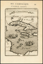
Spanish American War Era Map of Cuba and Environs
The Scientific American Navy Supplement Map of Cuba is an illustrative piece of cartography that provides not only geographical insights but also captures a unique historical moment. Issued alongside the Navy Edition of the Scientific American Supplement No. 1185, this map was created with the purpose of educating readers about the dynamics of the Spanish-American War, particularly in the Caribbean context.
The map primarily focuses on southern Florida, Cuba, and parts of the Bahamas. To offer broader context, three smaller inset maps were incorporated. The first of these shows the overall Caribbean area, revealing the relative position of Cuba within this broader regional geography. The second zooms in on Puerto Rico, an island also involved in the Spanish-American War. The third provides a close view of the area surrounding Havana, the capital of Cuba, a location of critical importance during this conflict.
The map's main emphasis is on Cuba's railroad network, highlighting its role as the backbone of transit and communication across the island. Around 20 small circles are used to spotlight cities and transit centers, underscoring their importance in the larger geopolitical context of the war. These markings serve as clear focal points, visually drawing the reader's attention to these critical locations. A military railroad is also shown traversing the country at its center, from north to South.
Further partitioning the map, Cuba's six provinces are each represented with a unique color, and their identification numbers are clearly marked. The provinces, at that time, were Pinar del Rio, Havana, Matanzas, Santa Clara, Puerto Principe and Santiago de Cuba. This visual distinction between provinces provides a clearer understanding of the territorial divisions within Cuba, allowing readers to gain insight into the regional dynamics at play during the Spanish-American War.
Beyond its geographical and political representation, the map stands as a piece of historical documentation. It encapsulates a snapshot of the Caribbean during the late 19th century and, more specifically, during a time of significant upheaval and conflict. By situating the Spanish-American War within its geographical context, the map provides an invaluable resource for understanding this critical period in the region's history.
Rarity
The map is apparently quite scarce. This is the first example we have ever seen.
![County Map of Florida [with Maps of North & South Carolina and inset of Charleston]](https://storage.googleapis.com/raremaps/img/small/92536.jpg)
![[ St. Augustine, Florida ] Pagus Hispanorum in Florida](https://storage.googleapis.com/raremaps/img/small/82983.jpg)
![[Mexico and Central America with Baja California inset, from Generalkarte von Nord America samt den Westindischen Inseln Versasst von Herrn. Pownall . . . MDCCLXXXVIII]](https://storage.googleapis.com/raremaps/img/small/95064.jpg)