


|
||

|

|
|

|
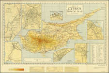
Survey map of Cyprus, still under British rule, issued by the War Office and Air Ministry in the midst of the Cyprus Emergency.
Topographic features, cities, district boundaries, roads, the Vasilikos–Drapia copper mine railway, airfields, and historic sites are shown. Royal Air Force Base Akrotiri appears, but the airfield at Kingsfield in Dhekelia was not yet built. A "disused airfield" just north of Tymbou (Tymvou or Kırklar) is today's Ercan International Airport in Northern Cyprus.
The Cyprus Emergency
The Cyprus Emergency, which occurred between 1955 and 1959, refers to a guerrilla war fought by the National Organization of Cypriot Fighters (EOKA) against British colonial rule and, to a lesser extent, the Turkish Cypriot minority. The conflict arose from the desire of Greek Cypriots for enosis, or union with Greece, in opposition to the British colonial government and Turkish Cypriots who favored partition. The guerrilla campaign, led by General George Grivas, targeted both British military personnel and infrastructure, as well as Turkish Cypriots at times. By 1959, the situation led to the London and Zurich Agreements, paving the way for Cyprus's independence in 1960. However, tensions between Greek and Turkish Cypriots persisted, leading to further conflict in the subsequent decades.

![Syrie Ancienne [shows Cyprus]](https://storage.googleapis.com/raremaps/img/small/89269.jpg)