|
||

|

|
|

|
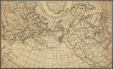
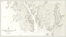
Colton's map of the Territory of Alaska captures the geographical and historical intricacies of Alaska. This map, one of the first separate representations of Alaska to grace a commercial atlas, is a noteworthy bit of cartographic history.
The map is richly populated with intricate details, meticulously denoting the contours of the land. It shows the broad expanses of the Alaskan wilderness, demarcated by sweeping lines that describe the rough borders of the vast territory.
The cartographic representation stretches beyond Alaska, including the contiguous Canadian and Pacific regions and parts of Russia, giving a wider geographical context to Alaska's position. The remarkable depiction of the Bering Strait acts as a bridge between two continents, emblematically encapsulating the narrative of Alaska's transition from Russian to American hands.
Upon closer inspection, the map is flecked with fascinating details. An array of early forts are illustrated, each serving as a reminder of the military importance of this frontier territory. The forts are positioned near the coastlines and along the major rivers, a testament to their role in securing critical trade routes and fending off potential threats. The forts listed include early American Forts, such as Fort Yukon, and Russian American Company Forts, such as Fort Alexander and Ft. Nicholas, which had by the 1870s been abandoned.
Beyond the geographical features, the map holds clues to the human history of Alaska. Small, strategically scattered markers represent early settlements, signifying the gradual encroachment of civilization into this wild land. They paint a picture of a frontier life dictated by geographical imperatives and survival needs.
To appreciate the map fully, one must delve into the history of Alaska. The 19th century was a period of immense change for this territory. The earlier part of the century saw Alaska under Russian control, with settlements primarily established for the fur trade. However, due to financial pressures and fearing the territory might be seized in a future conflict, Russia decided to sell Alaska to the United States in 1867.
Following the purchase, the territory remained largely unexplored until the end of the century. The discovery of gold in the Klondike region in the late 1890s ignited the Alaska Gold Rush. Thousands of prospectors arrived, pushing further into the interior in their quest for wealth, creating new settlements, and profoundly transforming the Alaskan landscape.
The "Colton's Territory of Alaska" map, in this context, serves as a silent chronicle of this transformative era. It embodies the intricate interplay of geography and human endeavor, the effects of political maneuvers and economic impulses, all etched into the geography of Alaska.
G. W. & C. B. Colton was a prominent family firm of mapmakers who were leaders in the American map trade in the nineteenth century. The business was founded by Joseph Hutchins Colton (1800-1893) who bought copyrights to existing maps and oversaw their production. By the 1850s, their output had expanded to include original maps, guidebooks, atlases, and railroad maps. Joseph was succeeded by his sons, George Woolworth (1827-1901) and Charles B. Colton (1831-1916). The firm was renamed G. W. & C. B. Colton as a result. George is thought responsible for their best-known work, the General Atlas, originally published under that title in 1857. In 1898, the brothers merged their business and the firm became Colton, Ohman, & Co., which operated until 1901, when August R. Ohman took on the business alone and dropped the Colton name.
![America [Manuscript Map Showing the Sea of the West!]](https://storage.googleapis.com/raremaps/img/small/41297dm.jpg)