|
||

|

|
|

|
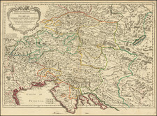
John Cary's A New Map of the Circle of Austria, From the Latest Authorities, published in London in 1801, offers an astute representation of Austria, standing as a notable example of early-19th-century British cartography. The map showcases a detailed landscape of the Austrian region, reflective of Cary's cartographic practice.
This map outlines the political boundaries of Austria, locating key cities, towns, and geographic landmarks with precision. Cary's dedication to accuracy is evident in his reliance on the latest authoritative sources of the time, indicating a commitment to providing a comprehensive and current depiction of Austria's terrain.
Historically, the map is situated in a critical phase of European history, the start of the 19th century. This was a period marked by the Napoleonic Wars and the reshaping of the political map of Europe. The delineation of Austria, a significant power player, provides insights into the regional dynamics of the time.
A New Map of the Circle of Austria, From the Latest Authorities stands as a noteworthy example of John Cary's influential work in the field of cartography. This map not only illuminates the geographical composition of Austria but also underscores the geopolitical intricacies of early 19th-century Europe. It is a testament to the interplay of cartography and history, illustrating the value of maps as historical documents.
John Cary (1755-1835) was a British cartographer and publisher best known for his clean engraving and distinct style which influenced the entire map industry. Born in Wiltshire, John was apprenticed to an engraver in London. He started his own business by 1782 and moved to several premises before settling at 86 St James’s Street in 1820.
Cary had several significant collaborations during his career. John Wallis and Cary diversified Cary’s business to include broader publishing projects. Brother William and John made globes together, while brother Francis participated in the company’s engraving work. Finally, geologist William Smith and Cary developed and sold geological maps, some of the first of their kind. The pair also produced a notable series of county maps starting in 1819. Cary’s atlases, of English counties and the world, were the standard texts of the early nineteenth century. He was appointed surveyor of roads to the General Post Office in 1794, which led to the New Itinerary, first published in 1798.
John trained his son, George, in engraving and George and his other son, John Jr., took over the business in 1821. It was then known as G. and J. Cary and continued in trade until 1850. The firm’s materials were then acquired by George Frederick Cruchley and then Gall and Inglis. By the time John died in 1835, Cary was the authoritative name in private map publishing and his business was a leader in the field throughout the first half of the nineteenth century.
![Carte de la Hongrie et des Pays qui en dependoient autresois dressée sur un grand nombre de memoire. . . 1703 [Map of Hungary and the countries that used to depend on it, previously drawn from a large number of records... 1703.]](https://storage.googleapis.com/raremaps/img/small/93871.jpg)
![[Salzburg] S.R.I Principatus et Archiepiscopatus Salisburgensis…](https://storage.googleapis.com/raremaps/img/small/94414.jpg)