|
||

|

|
|

|
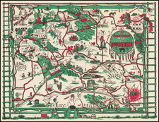
Published in Boston in 1964, Historic Massachusetts A Travel Map to help you feel at home in the Bay State is an enchanting pictorial travel map of Massachusetts, thoughtfully designed by Ernest Dudley Chase. A fine example of mid-20th century cartography, this version of the map presents a detailed panorama of the Bay State, richly adorned with pictorial illustrations and historical notes.
The map encapsulates the essence of Massachusetts, the landmarks, monuments, and cultural touchpoints that contribute to its unique character. Each vignette, meticulously curated by Chase, brings to life the state's historical points of interest, churches, sports venues, bridges, boating experiences, schools, and other noteworthy sites. Scattered across the map are intriguing snippets of historical trivia, such as the site of the telephone's invention or the location where Hawthorne penned The House of Seven Gables, seamlessly integrating the region's rich history and culture with its geography.
Variants
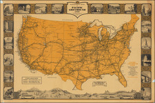
This map appears in at least two variants, one was handed out at the World's Fair in New York, and includes a route guide to the fair from Massachusetts.
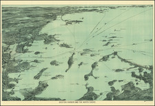
This is the standard, and probably earlier, variant. Instead of providing routes to the World's Fair grounds, this version includes an insightful inset of "Great Boston," capturing the essence of the city's layout. This element of the map offers a close-up view of the urban expanse of Massachusetts' capital and most populous city, underlining its status as the cultural and economic hub of the state.
Conclusion
In its entirety, Historic Massachusetts A Travel Map to help you feel at home in the Bay State presents a comprehensive and vivid depiction of Massachusetts as it was in the mid-20th century. Blending geographical detail with cultural and historical elements, this map is not just a navigational aid, but a reflection of the state's distinctive identity. As such, it remains a captivating artifact of historical significance, with an enduring appeal for scholars, collectors, and enthusiasts of Massachusetts' past.