|
||

|

|
|

|
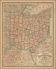
This informative map, published by the Ohio Department of Highway in 1965, serves as a pictorial guide to Ohio's mid-century transportation and logistics capabilities, highlighting the state's position as a significant hub of trade and transportation.
The map comes complete with a legend that uses illustrative symbols to indicate Ohio State Historical Properties, state universities and their branches, and state-assisted educational institutions. A note urges viewers to contact the Board of Regents for more detailed information about these educational establishments.
Licensed airports and the extensive railroad system are also marked, reflecting the importance of air and rail transport in Ohio's logistics network. The map, therefore, offers a useful visual overview of the state's transportation infrastructure.
Supplementing the cartographic data is further information furnished by various state departments, including the Ohio Bureau of Unemployment Compensation, the State Highway Department, the Department of Development, the Ohio Historical Society, and the Department of Natural Resources.
The map boasts the fact that Ohio, through its air, rail, truck, and waterway systems, transports over $15,250,000,000 worth of merchandise. Of this, $236,055,854 is exported to 83 countries worldwide. Detailed tables and graphics illustrate the extent of Ohio's trade with various international partners.
Adding a touch of cultural and historical flavor, the map's border features portraits of famous individuals from Ohio, a homage to the state's proud legacy. Overall, this map provides a snapshot of Ohio's 1960s status as a central transportation hub in America, adeptly blending geographic, economic, and historical elements into a single, comprehensive representation.
On the verso is a more straightforward travel Ohio For Fun It's Great Outdoors highway map.
![[ Ohio - Seven Ranges ] Plat of the Seven Ranges of Townships being Part of the Territory of the United States N.W. of the River Ohio which by a late act of Congress are directed to be sold . . . 1785](https://storage.googleapis.com/raremaps/img/small/82394.jpg)
![Cincinnati. From Covington [Letter from Philipp Holzmann]](https://storage.googleapis.com/raremaps/img/small/84432.jpg)
![Cincinnati and Environs [with] Business Portion of Cincinnati on Enlarged Scale](https://storage.googleapis.com/raremaps/img/small/84841.jpg)