|
||

|

|
|

|
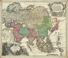
Rare map of Asia, published in Nuremberg.
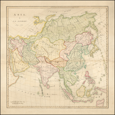
Asia, with its rich tapestry of history, cultures, and geographies, has always captured the imagination of explorers, geographers, and empires. The 1821 map, "Asien Nach den neuesten Reise beschreibungen, Charten und astronomischen Bestimmungen entworfen von I. N. Diewald," presents a captivating snapshot of the continent during a time of significant European influence and colonial expansion.
Published in Nuremberg by Christoph Fembo and based on the research and data provided by I. N. Diewald, the map promises accuracy and detail rooted in the latest travel descriptions, charts, and astronomical determinations. Such specificity and reliance on contemporary data undoubtedly made this map a valuable resource for its time.
European Possessions in East India and the Islands:
A unique aspect of the map is its vivid color-coding, representing the colonial footprints of European powers in East India and the surrounding island territories:
-
English (pink): The dominance of the British Empire in the Indian subcontinent is underscored by large swathes of pink. Their colonial jewel, India, is prominently featured, reflecting the British Raj's deep roots by the 1820s.
-
Dutch (yellow): The yellow regions primarily mark the Indonesian archipelago, showcasing the Dutch East Indies. Their influence spread across numerous islands, with Java being a significant center.
-
Portuguese (brown): Represented in brown, the Portuguese territories were notably smaller in comparison to their English or Dutch counterparts. Nevertheless, regions like Goa on the Indian west coast and pockets in Southeast Asia exhibit their historical influence.
-
Danish (purple): The Danes had smaller settlements and trading posts in Asia, with Tranquebar in India being one of the notable ones. Their purple shade on the map reflects these limited territories.
-
French (red): The French colonial ambitions in Asia had begun to solidify by the 1820s, especially in regions of modern-day Vietnam. The red regions on the map denote their growing influence in the continent, which would expand further in the coming decades.
-
Spanish (green): The Spanish empire's territories in Asia were primarily concentrated in the Philippines. The map's green patches in the island nation depict Spain's colonial stronghold.
-
Independent States (green): Interestingly, the same shade of green is used to mark both Spanish territories and independent states. These would be regions that remained outside European colonial control, reflecting the resilience of certain Asian powers and kingdoms.
![[ Ancient World ] Christianographie](https://storage.googleapis.com/raremaps/img/small/80305.jpg)