


|
||

|

|
|

|
Stock# 95989
Description
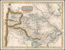
Map of Hudson Bay based on Jacques Nicholas Bellin's map of the area, "Carte des Parties du Nord-Ouest de l'Amerique," engraved by Veremondo Rossi and published by Livorno-based printer Marco Coltellini. Coltellini published Il Gazzettiere americano, the first Italian translation of J. Millar's American Gazetteer, which was published one year earlier in London. Giovanni Tommaso Masi republished the maps from Coltellini's edition in his atlas Atlante Dell'America in 1777.
The map shows the route of Henry Ellis' 1746 expedition across Hudson Bay in search of the Northwest Passage; much of the surrounding land remains "unknown." Fort Churchill, York Factory, and Prince of Wales Fort number among the few settlements mapped.
Condition Description
Minor faint foxing.
![Carte Qui Contient La Maniere Dont Se Fait La Chasse Des Bouefs Sauvages . . . [Buffalo, Niagara Falls, Calumet Village, Huron & Illinois Indians]](https://storage.googleapis.com/raremaps/img/small/93146.jpg)

![[ New France - Pierre Biard's Letter ] Missio Canadensis [in] Annuæ Litteræ Societatis Jesu Anni MDC.XI.](https://storage.googleapis.com/raremaps/img/small/84352.jpg)