


|
||

|

|
|

|
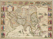
Fascinating map of Ancient Asia, from Morisot's Orbis Maritimi siue Rerum in Mari et Littoribus generalis historia: in qua inuentiones nauium, earundem partes, armamenta.
This map presented a unique view of the ancient maritime regions of Asia based on the knowledge and perceptions of the early 17th century.
One of the map's peculiarities is the depiction of Korea as an island. While we now recognize Korea as a peninsula, its delineation as an island was not an isolated occurrence in maps of this period due to limited geographical understanding.
Another geographical anomaly is the representation of the Philippines. The archipelago is shown much closer to the mainland and appears as an exaggerated cluster of islands. This portrayal might be attributed to the region's prominence in trade routes, coupled with imperfect cartographic information of the era.
The inclusion of the Straits of Anian is noteworthy. This supposed strait, believed to separate Asia and America, had long been speculated about. Its presence on Morisot's map reflects the ongoing quest for a northern passage between the Pacific and Atlantic.
Additionally, the Arctic Sea, labeled as "Mare Tartaricum", adds to the map's intrigue. The name possibly refers to Tartary, a vast region in Asia known but not comprehensively explored by Europeans at the time.

![[6 Sheet Wall Map of Asia] L'Asie divisee suivant l'Estendue de ses Principales Parties dans lesquelles sont distinguees les unes de autres Les Empires, Monarchies, Estats et Principaux Peuples qui partagent a present L'Asie . . . 1719](https://storage.googleapis.com/raremaps/img/small/80841.jpg)
![[Rare Complete Example with Game Pieces] Grand Circuit Des Capitales. Collection Concours Du Chocolat Menier](https://storage.googleapis.com/raremaps/img/small/70922rd.jpg)