|
||

|

|
|

|
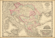
A New Map of Turkey In Europe, Divided into its Provinces is a detailed antique map published by John Cary in London in 1801. This map provides a comprehensive view of "Turkey in Europe", including Greece, Bosnia, Dalmatia, Serbia, Bulgaria, Moldova, Romania, and Albania, as well as the surrounding islands such as Cyprus and Crete.
Hand-colored by countries, this map offers clear distinctions between the various regions and provinces within the Ottoman Empire. The use of colors enhances the visual clarity of the boundaries and facilitates a better understanding of the political divisions in the area during the early 19th century.
Considered one of the best large-format English atlas maps of its time, Cary's map exemplifies the cartographic excellence of the period. The level of detail and precision displayed in this map reflects the dedication and skill of John Cary, a prominent mapmaker of the era. Its inclusion in an atlas signifies its importance as a reliable and authoritative source of geographical information.
A New Map of Turkey In Europe, Divided into its Provinces is a valuable resource for historians, geographers, and enthusiasts interested in the political and geographic landscape of the region during the early 19th century. Its detail and clear presentation make it a valuable tool for understanding the territorial divisions and boundaries of the time.
John Cary (1755-1835) was a British cartographer and publisher best known for his clean engraving and distinct style which influenced the entire map industry. Born in Wiltshire, John was apprenticed to an engraver in London. He started his own business by 1782 and moved to several premises before settling at 86 St James’s Street in 1820.
Cary had several significant collaborations during his career. John Wallis and Cary diversified Cary’s business to include broader publishing projects. Brother William and John made globes together, while brother Francis participated in the company’s engraving work. Finally, geologist William Smith and Cary developed and sold geological maps, some of the first of their kind. The pair also produced a notable series of county maps starting in 1819. Cary’s atlases, of English counties and the world, were the standard texts of the early nineteenth century. He was appointed surveyor of roads to the General Post Office in 1794, which led to the New Itinerary, first published in 1798.
John trained his son, George, in engraving and George and his other son, John Jr., took over the business in 1821. It was then known as G. and J. Cary and continued in trade until 1850. The firm’s materials were then acquired by George Frederick Cruchley and then Gall and Inglis. By the time John died in 1835, Cary was the authoritative name in private map publishing and his business was a leader in the field throughout the first half of the nineteenth century.
![[Corfu]](https://storage.googleapis.com/raremaps/img/small/40413.jpg)
![[Slovenia and the Duchy of Syrmia] Carte Du Royaume D'Esclavonie et Du Duche De Syrmie, dont l'un et l'autre est arrose par le Danube, l'Illove, La Save, et la Drave . . . 1783](https://storage.googleapis.com/raremaps/img/small/38566.jpg)