|
||

|

|
|

|
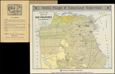
The Official Map of San Francisco Cal., created by George F. Cram in Chicago in 1892, is a remarkable and detailed cartographic treatment of the City by the Bay.
The map provides a comprehensive view of the city, highlighting various features such as wharves, dry docks, forts, streets, parks, rail lines, rivers, buildings, and wards. This level of detail offers valuable insights into the urban layout and infrastructure of San Francisco during the late 19th century.
In addition to its informational content, the map's aesthetic appeal is enhanced by the inclusion of an attractive compass rose, adding an artistic element to the overall design.
George F. Cram (1842-1928), or George Franklin Cram, was an American mapmaker and businessman. During the Civil War, Cram served under General William Tecumseh Sherman and participated in his March to the Sea. His letters of that time are now important sources for historians of the Civil War. In 1867, Cram and his uncle, Rufus Blanchard, began the company known by their names in Evanston, Illinois.
Two years later, Cram became sole proprietor and the company was henceforth known as George F. Cram Co. Specializing in atlases, Cram was one of the first American companies to publish a world atlas. One of their most famous products was the Unrivaled Atlas of the World, in print from the 1880s to the 1950s.
Cram died in 1928, seven years after he had merged the business with that of a customer, E.A. Peterson. The new company still bore Cram’s name. Four years later, the Cram Company began to make globes, a branch of the business that would continue until 2012, when the company ceased to operate. For the final several decades of the company’s existence it was controlled by the Douthit family, who sold it just before the company was shuttered.
![[ First Printed Map of San Francisco Bay ] Plan Du Port De St. Francois Situe sur la cote de la Californie . . .](https://storage.googleapis.com/raremaps/img/small/90983.jpg)
![[San Francisco Earthquake and Fire] Destruction of San Francisco By Earthquake and Fire, April 18th 1906 / Every Building Shown In the Above Picture Was Destroyed by the Great Fire](https://storage.googleapis.com/raremaps/img/small/88832.jpg)