


|
||

|

|
|

|
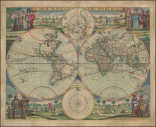
The Cloverleaf Map of the World
Heinrich Buenting's Die Gantze Welt in einem Kleberblat, produced in Helmstadt in 1582, is a compelling example of the innovative cartography that marks this era of exploration. Known as the clover leaf map of the world, it is an important part of Buenting's magnum opus, Itinerarium Sacrae Scriptura, first published in Helmstadt in 1581.
In this intriguing geographical representation, the world takes on a Holy Land-centric perspective, reflecting the scriptural understanding of the earth. In the center, Jerusalem serves as the heart of the world, drawing on the T-O model widely used in medieval map-making. The three leaves of the clover encircle Europe, Africa, and Asia, whereas regions like England, Scandinavia, and America lie outside these primary circles.
As a theological commentator hailing from Hanover, Buenting sought to fuse religious context with geographical exploration in his work. His Itinerarium Sacrae Scriptura is celebrated for its inventive thematic maps, including depictions of Europe as a Queen and Asia as Pegasus. Notable details such as sea monsters, mermaids, and a large sailing ship embellish the ocean spaces, adding an element of the fantastical to the scientific endeavor of cartography.
The title of this distinctive world map translates as "The Whole World in a Cloverleaf, Which is the Coat of Arms of Hannover, My Dear Fatherland," a testament to Buenting's personal connection to his place of origin. Given its unique design and historical significance, it is not surprising that Buenting's map is among the most sought-after 16th-century world maps, a veritable treasure for those with an appreciation for the intersection of cartography, history, and theology.
Henrich Bunting was a Protestant theologian and teacher born in Hanover, in what is now Germany. He attended the University of Wittenberg and graduated in 1569. He then began work as a preacher but caused some controversy with his teachings; he was dismissed from appointments in both Lemgo and Goslar.
He is best known today for his book, Itinerarium Sacrae Scripturae (Travel book through Holy Scripture), a travel collection and commentary of the geography of the Bible. The book provided the most complete summary of biblical geography then available and described the Holy Land by following the travels of various notable people from the Old and New Testaments. First published in Madgeburg in 1581, Itinerarium Sacrae Scripturae was a very popular book for the time. Over 60 editions were published between 1581 and 1757.
A particularly notable feature of the book were its many woodcut maps, many of them showing unique depictions of geographic features and continents. In addition to the conventional maps, the book also contained three figurative maps; the world depicted using a cloverleaf design (thought to possibly represent the Trinity with Jerusalem in the center), Europe in the form of a crowned and robed woman, and Asia as the winged horse Pegasus.
![Newsmap. Monday, July 27, 1942 [on verso:] Tanks of the British Army](https://storage.googleapis.com/raremaps/img/small/93349.jpg)
![[ Florida Native Americans Declaring War ] Bellum denunciandi ratio. XXXIII.](https://storage.googleapis.com/raremaps/img/small/98006.jpg)
![[Volcanos and the Subterranean World] Tabula Geographico-Hydrographica Motus Oceani, Currentes, Abyssos, Montes Igniuomos In Universo Orbe Indicans, Notat Haec Fig. Abyssos Montes Vulcanios](https://storage.googleapis.com/raremaps/img/small/95720.jpg)