|
||

|

|
|

|
Massive Indiana Territory and Unnamed Illinois Territory
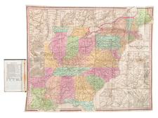
Fine example of Pierre Tardieu's monumental 4-sheet map of the United States, one of the best large format maps of the United States from the period.
Tardieu's map was first created following the publication of the first state of Arrowsmith's map of the United States. Using Arrowsmith's map as a based template, Tardieu creates a new map, which reflects the finer engraving skills of this Paris engraver. Over the next 18 years, Tardieu's regularly updated and improved his map, often in advance of improvements by Arrowsmith, who also periodically updates his 4 sheet map for the next several decades.
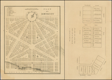
In addition to copying the decorative cartouche present in Arrowsmith's map, Tardieu has added a plan of Washington DC, based upon Andrew Ellicott's official plan for America's newly minted Capital City.
The map is a landmark of American Cartography prior to Lewis & Clark. The interior detail of the trans-Mississippi west was compiled largely from accounts supplied by Native Americans to Arrowsmith, by the Hudson's Bay Company. The course of the Missouri River delineated on the map prompted Lewis and Clark to plot their course along the Missouri River, as it appeared to be the most direct route to the Pacific.
The present map came to the attention of Thomas Jefferson, who specifically reached out to the Tardieu family to update the map. The Tardieus family exchanged maps with Thomas Jefferson on several occasions, specially in aid of the Tardieu's efforts to incorporate information from Lewis & Clark and others into their maps (see, e.g. letter from P.A.F. Tardieu to Jefferson dated May 30, 1809). Thomas Jefferson wrote to Tardieu on one occasion, thanking him for his excellent maps of the United States and the Bay of Mexico, and in return, Jefferson sent Tardieu a survey of the Mississippi River from its source to the mouth of the Ohio, and promises a map of Louisiana from "Gov. Lewis, who conducted the journey to the South Sea as soon as it appears."
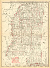
State 3: Introduction of Mississippi Territory, Indiana Territory & West Florida
Mississippi Territory: The Mississippi Territory, established in 1798, had boundaries that underwent numerous adjustments before the eventual emergence of the states of Mississippi and Alabama. The Mississippi Territory was created from land ceded to the United States by Georgia, initially extending from the 31st parallel northward to the 32nd parallel, and from the Mississippi River in the west to the Chattahoochee River in the east. The territory was small and irregular in shape, situated south of the Yazoo River and limited to parts of present-day southern Mississippi and southwestern Alabama. The 1798 boundaries essentially carved out a section of the vast area between Spanish Florida to the south and the evolving American territories and states to the north and east.
The first significant expansion occurred in 1804 when the northern boundary was extended up to the Tennessee River, absorbing a large portion of the lands claimed by Georgia. This was a direct result of the 1802 Compact between Georgia and the Federal government, in which Georgia ceded its western claims in return for the removal of Native Americans from the eastern parts of the state. This expansion effectively doubled the size of the territory and included portions of present-day northern Alabama.
A subsequent modification took place after the United States acquired West Florida from Spain in 1812. While the entirety of West Florida was not incorporated into the Mississippi Territory, parts of it were. This inclusion stretched the southern boundary of the territory to the Gulf of Mexico, thereby affording it a coastal front.
Further alterations occurred as a result of treaties with Native American tribes such as the Choctaw and Creek. Land sessions in the early 19th century, often achieved through coercive tactics, allowed for eastern expansions. By this point, the Mississippi Territory had grown substantially both in size and strategic importance, taking on much of its eventual shape, save for its division into the states of Mississippi and Alabama in 1817.
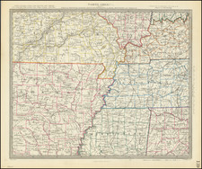
Indiana Territory: The boundaries of the Indiana Territory underwent several significant alterations from its establishment in 1800 until it achieved statehood in 1816. Created from the western section of the Northwest Territory, the Indiana Territory originally encompassed not only present-day Indiana but also Illinois, Wisconsin, parts of Michigan, and Minnesota east of the Mississippi River.
Initially, the Indiana Territory was a vast expanse stretching from the Ohio River in the south to the Great Lakes in the north, and from the Mississippi River in the west to the border with Ohio in the east. It was established through the Indiana Organic Act, signed by President John Adams on May 7, 1800. However, this gargantuan tract of land was untenable for effective governance, especially given the relatively low population density and the logistical challenges of the time.
The first major change occurred in 1805 when the Michigan Territory was carved out of the Indiana Territory, taking with it the lands around and north of the southern tip of Lake Michigan. The Indiana Territory underwent another significant reduction in size in 1809. The Illinois Territory (unnamed on this map) was created out of its western sections, including all of present-day Illinois and Wisconsin.
States of the Map
The map is known in 6 states:
- State 1: 1802 (dated)
- State 2: 1808 (adding Michigan Territory, Ohio, Vermont, Kentucky & Tennessee).
- State 3: 1812 (dated) Mississippi Territory, Indiana Territory, West Florida is shown, Louisiana does not yet appear as a state and there is a massive area called Indiana below lake Michigan, with an unnamed Territory to the west.
- State 4: (circa 1816), adds Illinois Territory and a massive Northwest Territory.
- State 5: (circa 1818), Alabama Territory appears for the first time, the roads in Illinois Territory and Indiana Territory have been changed and East Florida and West Florida are no longer named.
- State 6: 1820. Adds an additional set of half-sheets at the bottom of the map, extending the map's coverage to include all of Florida.
Rarity
All states of the map are scarce to rare. The final state is by far the rarest.
Pierre Antoine Tardieu (1784-1869), also known to sign his works as PF Tardieu, was a prolific French map engraver and geographer. The Tardieu family, based in Paris, was well known for their talent in engraving, cartography, and illustration. Pierre Antoine’s father, Antoine Francois Tardieu, was an established cartographer who published numerous atlases. His son is said to have collaborated with him for many years before establishing his own independent career.
Pierre Antoine Tardieu’s most famous work includes engravings of the islands of La Palma and Tenerife, for which in 1818 he was awarded a bronze medal by King Louis-Phillipe for the beauty and accuracy of his mapping. Other famous work includes his mapping of Louisiana and Mexico, engravings of Irish counties, maps of Russia and Asia, and his highly celebrated illustrations of all the provinces of France. He was also the first mapmaker to engrave on steel.
Tardieu was a popular map engraver in his lifetime, enjoying the patronage of the likes of Alexander von Humboldt and respect among his peers. In 1837, he was appointed the title Chevalier de la Légion d’honneur. As was written in his obituary in the Bulletin of the Geographical Society of France, he was renowned for his combination of technical talent and scholarly research skills and praised for furthering his family’s well-respected name in the scientific arts.
![[United States Independence After The Revolution] A New Map of North America, with the West India Islands, Divided according to the Preliminary Articles of Peace, Signed at Versailles, 20 Jan. 1783, wherein are particularly Distinguished The United States, and the Several Provinces, Governments &ca, which Compose the British Dominions . . . 1783](https://storage.googleapis.com/raremaps/img/small/70734.jpg)
![[ Atlas - Florida and Southern Canal Projects ] Travaux d'améliorations intérieurs projetés ou exécutés par le gouvernement général des États-Unis d'Amérique, de 1824 à 1831 [complete with:] Travaux d'améliorations intérieurs projetés ou exécutés... Atlas.](https://storage.googleapis.com/raremaps/img/small/85067.jpg)