


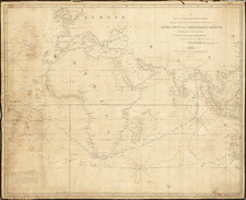
|
||

|

|
|

|
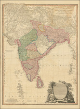
Map of the Province of Malabar produced by Aaron Arrowsmith and published in 1809 in London, captures the vast region of Malabar, in southwest India. It spans from the scenic north-eastern hilly terrain of Wayanad to the southern reaches of Cochin and parts of Travancore, while encapsulating the Indian Ocean to the west and stretching east to Seringapatam.
Aaron Arrowsmith's map provides a rich visual record of the province of Malabar at the outset of the 19th century. The map is infused with a wealth of geographical details, including the delineation of rivers, mountains, and forests. Beyond the physical geography, the map also provides critical insights into the socio-political landscape of the time. It incorporates elements such as the political boundaries, major settlements, and transportation routes, creating an intricate historical snapshot of the region during this period.
The late 18th century, just before when this map was drawn, was a tumultuous period in Indian history, with ongoing conflicts between the British East India Company and various Indian factions. The notorious Anglo-Mysorean Wars exemplified the colonial powers' quest to dominate the region's trade and resources. Arrowsmith's map subtly captures these tensions, with notations such as "Irenaar given up to the Talcavey" and "Pangeah, was given up by the Rajah of Coork to Trippoo in 1792," marking the territorial shifts resultant from these conflicts.
Of note is the map's depiction of part of the Nedumkotta or Travancore lines. These extensive fortifications, stretching about 65 km from Padmanabhapuram in the south to Paravur in the north, were erected to protect the Travancore kingdom from incessant invasions. During the Third Anglo-Mysore War, the lines withstood the British East India Company's assault, ultimately contributing to the war's stalemate. Thus, Arrowsmith's map not only represents a rich geographical resource but also stands as a testament to the historical complexities and contestations of the early 19th-century Malabar region.
Rarity
Very rare. OCLC locates copies only at Wurttembergische Landesbibliotherk and Bibliotheque Nat & Univ Strasbourg.
The Arrowsmiths were a cartographic dynasty which operated from the late-eighteenth century to the mid-nineteenth. The family business was founded by Aaron Arrowsmith (1750-1823), who was renowned for carefully prepared and meticulously updated maps, globes, and charts. He created many maps that covered multiple sheets and which were massive in total size. His spare yet exacting style was recognized around the world and mapmakers from other countries, especially the young country of the United States, sought his maps and charts as exemplars for their own work.
Aaron Arrowsmith was born in County Durham in 1750. He came to London for work around 1770, where he found employment as a surveyor for the city’s mapmakers. By 1790, he had set up his own shop which specialized in general charts. Arrowsmith had five premises in his career, most of which were located on or near Soho Square, a neighborhood the led him to rub shoulders with the likes of Joseph Banks, the naturalist, and Matthew Flinders, the hydrographer.
Through his business ties and employment at the Hydrographic Office, Arrowsmith made other important relationships with Alexander Dalrymple, the Hudson’s Bay Company, and others entities. In 1810 he became Hydrographer to the Prince of Wales and, in 1820, Hydrographer to the King.
Aaron Arrowsmith died in 1823, whereby the business and title of Hydrographer to the King passed to his sons, Aaron and Samuel, and, later, his nephew, John. Aaron Jr. (1802-1854) was a founder member of the Royal Geographical Society (RGS) and left the family business in 1832; instead, he enrolled at Oxford to study to become a minister. Samuel (1805-1839) joined Aaron as a partner in the business and they traded together until Aaron left for the ministry. Samuel died at age 34 in 1839; his brother presided over his funeral. The remaining stock and copper plates were bought at auction by John Arrowsmith, their cousin.
John (1790-1873) operated his own independent business after his uncle, Aaron Arrowsmith Sr., died. After 1839, John moved into the Soho premises of his uncle and cousins. John enjoyed considerable recognition in the geography and exploration community. Like Aaron Jr., John was a founder member of the RGS and would serve as its unofficial cartographer for 43 years. Several geographical features in Australia and Canada are named after him. He carried the title Hydrographer to Queen Victoria. He died in 1873 and the majority of his stock was eventually bought by Edward Stanford, who co-founded Stanford’s map shop, which is still open in Covent Garden, London today.
![[Karaikal] Carte Reduite du Territoire de Karikal](https://storage.googleapis.com/raremaps/img/small/59318.jpg)
![Colonel Mordaunt's Cock Match at Lucknow [Key Image]](https://storage.googleapis.com/raremaps/img/small/86563.jpg)
![[Portrait] L'Asie.](https://storage.googleapis.com/raremaps/img/small/79746.jpg)
![Rangoon [Yangon, Birmah]](https://storage.googleapis.com/raremaps/img/small/90251.jpg)