|
||

|

|
|

|
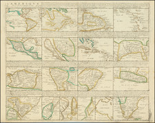
Jesuit Map of the Caribbean
Finely engraved early 18th-century map by of the Spanish Main by Heinrich Scherer.
The map offers a detailed view of the Caribbean region, extending from the lower part of Florida to the northern coast of South America, and from the Yucatan Peninsula to the eastern islands of the Caribbean. It accurately marks key locations such as principal ports, settlements, cities, and rivers across the islands. Additionally, the map is adorned with illustrations of ships, reefs, and mythical sea creatures, enhancing its visual appeal.
The map includes distinct markings to identify the territories controlled by European powers like Spain, France, and Britain, as well as areas inhabited by the indigenous Carib populations.
A notable feature is the map's decorative elements, which not only add to its attractiveness but also provide insights into the interactions between European traders, explorers, settlers, and the native peoples of the Caribbean, depicted through a detailed scene in the map's top right corner.
![Amer. Sep. No. 69. Porto-Rico [and the Virgin Islands]](https://storage.googleapis.com/raremaps/img/small/42102.jpg)
![West Indies and Central America [Bermuda inset]](https://storage.googleapis.com/raremaps/img/small/89941.jpg)