|
||

|

|
|

|
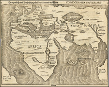
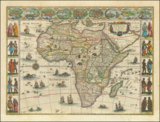
Aphrica, an early 17th-century map of the African continent, was produced by Johann Bussemacher in Cologne in 1600 under the supervision of the renowned German cartographer Matthias Quad. Drawing inspiration from the Mercator world map of 1569 and subsequent Mercator Africa map of 1595, this map integrates both the geographical accuracy of its time and subtle adaptations.
The onset of the 17th century heralded a defining phase in cartographic history. As European powers expanded their maritime explorations, the demand for precise and detailed maps surged. Within this milieu, the city of Cologne emerged as a vital nexus for cartographers, engravers, and geographers, and talents like Quad took the lead in crafting intricate geographical works. Despite facing potential challenges because of his Protestant faith, Quad's cartographic contributions, occasionally under pseudonyms, reflect the period's complex intersection of faith, science, and artistry.
This map's revised depiction of Madagascar sets it apart from previous works. This and other adjustments highlight the iterative approach to map-making, where cartographers built on previous works while pushing for enhanced precision and clarity.
The mysterious southern lake, a geographical entity of enduring debate during the era, is depicted as the origin for several of the continent's major rivers, including the Zaire Rio (Congo), the rivers flowing into the Indian Ocean, and even the Nile.
Although Aphrica made its debut in Quad's Geographisch Handtbuch of 1600, other works of the period, such as Quad's Fasciculus Geographus of 1608 and Giovanni Botero's Allgemeine Historische Weltbeschreibung of 1611, also featured it. Interestingly, an earlier claim regarding the map's presence in Quad's 1596 travel book, Europae totius terrarum orbis..., remains unverified.
Matthias Quad (1557-1613), a map publisher based in Cologne, was trained in the Netherlands by Johannes van Doetecum, who also worked with the De Jodes. Quad used many De Jode maps as a base to which he added additional information and decorations. Quad was best known for his atlases, which were part of the first boom in atlases best characterized by Abraham Ortelius’ Theatrum Orbis Terrarum. In 1592, Quad released an atlas of Europe that had 38 maps. He expanded it in 1594 to 50 maps. In 1600, he expanded the collection of maps further still, this time to 82 maps, and called the atlas, Geographisch Handtbuch. All three were small in size, allowing them to compete as cheaper alternatives to the larger atlases of Ortelius, Mercator, and the De Jodes. Quad released one other atlas, in 1608, with 86 maps, the Fascilus Geographicus.
![[ Africa ] Philips' Graphic Relief Wall Maps](https://storage.googleapis.com/raremaps/img/small/102098.jpg)