


|
||

|

|
|

|
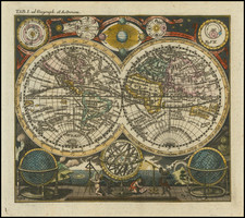
Rare First State, Published by Nicolas Berey. Recorded only in Shirley's Addenda.
A beautiful example of this 17th-century French double-hemisphere world map, made by Pierre Du Val and published by Nicolas Berey in 1661.
The map represents an exciting moment in historical cartography, as it was produced when French mapmakers were becoming internationally recognized as some of the best geographers of their time. The map shows early Tasman information, and interprets New Zealand to be a part of the great southern continent. In North America, Berey follows the Sanson model for showing all five Great Lakes. The "Tierre de Iesso," also labeled "Anien" (Anian), nearly connects North America and East Asia.
The map is decorative in the French style. Above and below the hemispheres are maps of the northern and southern night skies. At the four corners are depictions of the cardinal directions (in French and Latin), the winds, and the climatic zones. Lengthy French texts on geography accompany the map, and the map has also been heavily annotated in a contemporary hand. These annotations focus primarily on maritime geography and on the climate.
States and Editions
This state of the map is unrecorded in Shirley's original cataloging, and appears only in his corrigenda and addenda. Shirley records the first state of the map as the 1666 edition published by Jaillot.
In addition, we recently discovered an unrecorded edition of the map printed from a different copperplate but bearing the same title. The states can be recorded as follows:
First edition:
- State 1: Dated 1661, with Berey as the publisher.
- State 2: Dated 1668, with Jaillot as the publisher.
- State 3: Dated 1678, with Jaillot as the publisher.
Second edition:
- Dated 1682, with Jaillot as the publisher.
It is possible that Jaillot published the second edition with a new 20-year privilege as soon as the privilege on the first edition ran out. Other than the date, the cartographic information in the two editions appears identical.
Pierre Duval (1618-1683) was a French geographer, cartographer, and publisher who worked in Abbeville and Paris during the seventeenth century. He was born in the former city, in northeast France, before moving to Paris. Duval was the nephew of the famous cartographer Nicolas Sanson, from whom he learned the mapmaker's art and skills. Both men worked at the royal court, having followed the royal request for artists to relocate to Paris. In addition to numerous maps and atlases, Du Val's opus also includes geography texts. He held the title of geographe ordinaire du roi from 1650 and died in 1683, when his wife and daughters took over his business.
![[ Polyglot Continents ] Europa Poly Glottia Linguarum Geneologiam exhisbens [with] Asia Poly Glottia [with] Africa Poly Glottia [with] America cum Supplementis Poly-Glottis](https://storage.googleapis.com/raremaps/img/small/105332.jpg)
![(Apian World Map) La Cosmographia de Pedro Apiano, corregida y añadida por Gemma Frisio ... El Sitio y Descripcion de las Indias y Mundo Nuevo, sacada de la Historia de Francisco Lopez de Gomara, y de la Cosmographia de Ieronymo Giraua Tarragonez [with map:] Mappa Mundi](https://storage.googleapis.com/raremaps/img/small/100234.jpg)
![[Wall Map] Orbis Terrarum Nova et Accurata Tabula. Auct. G. Valck.](https://storage.googleapis.com/raremaps/img/small/41630dc.jpg)