|
||

|

|
|

|
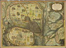
Mapping Jerusalem has always been an intricate endeavor due to the city's multifaceted religious and historical significance. One notable map from the late 17th andearly 18th century is Daniel Stoopendaal’s town plan of Jerusalem, which also inspired copies such as this English language map. This map, inspired by Ezekiel's prophecies, offers a blend of religious and geographical representation.
The central feature of the map is the detailed town plan of Jerusalem. Stoopendaal incorporates various landmarks, each significant in Judeo-Christian traditions. To further guide the viewer, accompanying legends list 57 additional sites, serving as a reference point to the city’s topography.
Stoopendaal’s reliance on Ezekiel’s prophecies for his map is an interesting choice. Ezekiel, known for his visions, especially concerning the reconstruction of the Temple, gives the map a layer of religious significance. This choice suggests an intent to reflect both the historical and prophetic dimensions of the city.
The translation of Stoopendaal’s map into English during the 1700s highlights the growing interest in biblical lands among English speakers. As England's influence expanded, so did its citizens' curiosity about historically and religiously significant regions.
![[ Jerusalem ] Die Heilige Statt Jerusalem Contrafehtet nach Form und Gestalt wie sie Ietz Erbauwen ist](https://storage.googleapis.com/raremaps/img/small/88642.jpg)
![(Jerusalem - Temple of Salomon) Templum Salomonis [with Perugia on verso]](https://storage.googleapis.com/raremaps/img/small/96662.jpg)