


|
||

|

|
|

|
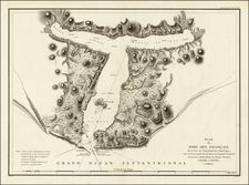
Rare early 19th Century map of "Russian America" and the contiguous regions, published in Leipzig.
The map includes a number of regions which appear to relate to various indigenous peoples. The names used below appear in German language descriptions of the native peoples of Alaska in the mid-19th Century.
-
Land der Kenaizen: This likely refers to the Kenaitze or Dena'ina people, indigenous to the Kenai Peninsula. The Dena'ina are the only Athabaskan group that resides on the coast, known for their rich oral traditions and intricate fish trap systems.
-
Land der Tschugatschen: A possible reference to the Chugach people, native to the Prince William Sound and the Kenai Peninsula. Renowned for their sea faring skills, the Chugach had a complex society that thrived on maritime resources.
-
Land der Ugataschmiuten: Likely refers to a subgroup of the Yup’ik people, demonstrating the importance and reach of the Yup’ik in Alaskan history.
-
Land der Koljuschen: This is indicative of the Koyukon people, an Athabaskan group living along the Yukon and Koyukuk rivers.
-
Land der Kitegnen: Were a people observed by Captain James Cook in the Arctic Ocean regions.
Schleiben's atlas was published in at least 15 parts and is extremely rare on the market.
The map shows Alaska toward the end of Russia's active period of colonization. After a period of exploitation by the Shelikhov-Golikov Company, in 1799, Grigory Ivanovice Shelikhov's son-in-law, Nikolay Petrovich Rezanov, acquired a monopoly on the American fur trade from Czar Paul I and formed the Russian-American Company. As part of the deal, the czar expected the company to establish new settlements in Alaska and carry out an expanded colonization program.
By 1804, Alexander Baranov, now manager of the Russian–American Company, had consolidated the company's hold on the American fur trade following his victory over the local Tlingit clan at the Battle of Sitka. Despite these efforts the Russians never fully colonized Alaska. The Russian monopoly on trade was also being weakened by the Hudson's Bay Company, which set up a post on the southern edge of Russian America in 1833.
In 1818 management of the Russian-American Company was turned over to the Imperial Russian Navy and the Ukase of 1821 banned foreigners from participating in the Alaskan economy. It soon entered into the Anglo-Russian Convention of 1825 which allowed British merchants to trade in Alaska. The Convention also settled most of the border between Alaska and British North America.
The Russo-American Treaty of 1824, which banned American merchants above 54° 40' north latitude, was widely ignored and the Russians' hold on Alaska weakened further.
Rarity
The map is rare on the market. This is the first time we have offered this map for sale.
![[ Sea of the West ] L'Amerique Septentrionale divisee en ses principaux Etats . . . 1782](https://storage.googleapis.com/raremaps/img/small/80228.jpg)
![[ Pacific Northwest - Northwest Passage ] Limes Occidentis Quivira et Anian. 1597](https://storage.googleapis.com/raremaps/img/small/71207.jpg)