|
||

|

|
|

|
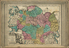
Carte Geographique Contenant le Royaume de Siberie, engraved by Matthäus Albrecht Lotter, offers a detailed geographical portrayal of Siberia, divided into its three main provinces: Tobolsk, Yeniseysk, and Irkutsk, with additional regions of Tartary included. An inset map of the Chukchi Peninsula appears in the upper right corner, and the map's cartouche, situated on the left sheet, presents a Siberian steppe landscape complete with a reindeer sledge, whale, and polar bears, immersing the viewer in the Siberian environment.
This map, though undated, probably appeared between 1770-1780. This dating is inferred from its similarity in content and design to a Siberian map by Ivan Fomic Truscot published circa 1770, which encompassed only the West Siberian states of Tobolsk and Yeniseiesk. Additionally, the map showcases striking resemblances to the representations on Rigobert Bonne’s maps of Russia and the Chinese Tartary, particularly evident in the depiction of Sakhalin Island. While previous maps, including Truscot’s 1776 version, often depicted Sakhalin as more stout, Lotter's rendition offers a slimmer shape that aligns more closely with the island’s actual form. Notably, Cape Patience is integrated with Sakhalin, marking a shift from prior representations.
Jeso's depiction, occupying a significant part of the Sea of Japan, and the representation of the Kurile Islands adjacent in the northeastern direction are reminiscent of several 18th-century maps. However, the lack of a clear chain of islands designation for the Kuriles and the unique denominations of islands such as Terre des Etat (Iturup) and Terre de la Compagnie, both marked with reference hints to Russian maps, underscore Lotter's methodical sourcing from diverse materials and not merely replicating an existing map.
One distinct continuity in this map is the depiction of the Chukchi Peninsula, retaining its shape from Ivan Kirilov’s 1734 general map. The portrayal of Novaya Zemlya without the Matochkin Strait further adds to the uniqueness of this work, potentially reflecting Lotter’s decision to either adhere to traditional forms or base the representation on older data.
In essence, Carte Geographique Contenant le Royaume de Siberie stands as a synthesis of Lotter's careful assimilation of various sources, combined with his own interpretative decisions, offering viewers a comprehensive view of Siberia during the latter part of the 18th century.
Tobias Conrad Lotter (1717-1777) is one of the best-known German mapmakers of the eighteenth century. He engraved many of the maps published by Matthaus Seutter, to whose daughter Lotter was married. He took over Seutter’s business in 1756. Lotter’s son, M. A. Lotter, succeeded his father in the business.

![[Alaska, Northwest Coast and North Pacific Ocean] Der Noerdliche Theil des Grossenwelt Meeres . . . 1804](https://storage.googleapis.com/raremaps/img/small/80463.jpg)