|
||

|

|
|

|
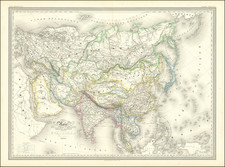
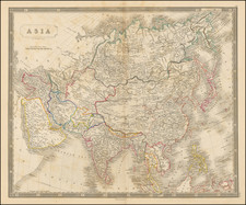
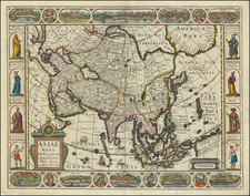
Titled Asia cum omnibus Imperiis, Provinciis Statibus et Insulis, this 1730 map by Matthaeus Seutter from Augsburg offers a richly detailed view of Asia, including an incomplete portrayal of Australia and speculative regions north of Japan. Noted for their artistry, Seutter's maps are highly coveted from the period, and this particular rendering stands as an exceptional representation of both geographical knowledge and cartographic skill of its time.
Situated within the era of exploration and colonial expansion, the map embodies European efforts to chart and understand the vast continent of Asia, its adjoining islands, and beyond. The inclusion of speculative regions and inaccurately depicted territories, such as "Terra Yedso" and the vicinity of the present-day Bering Strait, reflects the limitations and misconceptions of geographical knowledge during this period. The reference to "Comapgnie Land" and the voyage of Don Jean de Gama adds to the historical intrigue, providing insight into the exploratory endeavors that shaped European understanding of the East.
The map's details, captured through Seutter's renowned engraving technique, offer not only geographical information but also cultural and socio-political insights. The elaborately-engraved cartouche in the upper right corner addresses the reader in Latin, commenting on the wondrous yet woeful condition of the inhabitants of Asia. This commentary, intertwined with references to gemstones, silk, gold, and silver, paints a vivid picture of a land rich in material goods but described as lacking in spiritual wealth. This perspective sheds light on the cultural biases and aspirations that influenced European engagement with Asia during the early 18th century.
In terms of artistic and historical significance, Asia cum omnibus Imperiis, Provinciis Statibus et Insulis serves as a masterful example of cartography from an era marked by curiosity, exploration, and often-misguided understanding. The map's combination of geographical depiction, speculative content, artistic embellishment, and socio-cultural commentary makes it an invaluable artifact. It stands not only as a representation of Asia as perceived in the 18th century but also as a complex document reflecting broader themes of exploration, colonization, commerce, and cultural interaction.
Matthäus Seutter (1678-1757) was a prominent German mapmaker in the mid-eighteenth century. Initially apprenticed to a brewer, he trained as an engraver under Johann Baptist Homann in Nuremburg before setting up shop in his native Augsburg. In 1727 he was granted the title Imperial Geographer. His most famous work is Atlas Novus Sive Tabulae Geographicae, published in two volumes ca. 1730, although the majority of his maps are based on earlier work by other cartographers like the Homanns, Delisles, and de Fer.
Alternative spellings: Matthias Seutter, Mathaus Seutter, Matthaeus Seutter, Mattheus Seutter
![Expedition Citroen Centre-Asie 3eme Mission G.-M. Haardt - L. Audouin-Dubreuil [with 2 official pamphlets for the route, etc.]](https://storage.googleapis.com/raremaps/img/small/63033.jpg)