


|
||

|

|
|

|
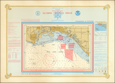
An authoritative nautical chart of Santa Monica Bay, California, this 1974 map is a product of the United States Department of Commerce's National Ocean Survey (NOS). The chart showcases a large-scale view of the area, interspersed with minute hydrographic and topographic details, soundings in fathoms at mean lower low water, and accompanying inserts featuring Marina Del Rey and King Harbor.
In the midst of a transformative period in American cartography, this chart embodies the rigor and precision of the National Ocean Survey, the forerunner of the National Oceanic and Atmospheric Administration (NOAA). It was produced in 1974, a time when geospatial sciences were expanding rapidly, fueled by new technologies and applications in diverse fields such as oceanography, environmental management, and military navigation. These developments greatly enhanced the quality and accuracy of maps and charts, making them invaluable resources for seafarers and researchers alike.
This particular chart, with its Mercator projection at a scale of 1:40,000, offers a comprehensive view of Santa Monica Bay. Detailed soundings in fathoms facilitate a deep understanding of the bay's underwater topography, while the inclusion of the California State Grid Zone VII provides a geographical context that allows for accurate positioning and navigation. The inset of Marina Del Rey at a scale of 1:10,000 and the inclusion of King Harbor further augment the chart's utility by offering detailed views of these significant harbors.
The array of authorities listed, which includes the Corps of Engineers, Geological Survey, and US Coast Guard, underscores the breadth of data collection involved in creating this piece. As such, it serves not merely as a navigational aid, but also as an artifact that encapsulates the collaborative nature of national survey efforts. Ultimately, this chart represents a moment in the rich history of American cartography, demonstrating the country's commitment to comprehensive, accurate, and accessible marine mapping in the mid-20th century.
![[Los Angeles] Metro Greenline](https://storage.googleapis.com/raremaps/img/small/96817.jpg)
![(Los Angeles Architecture) [Photograph of a 1920s Spanish Colonial Revival home, likely in the Hollywood Hills area; with glass plate negative]](https://storage.googleapis.com/raremaps/img/small/96755.jpg)
![[Southern California Citrus Fair Promotional Broadside] Riverside Exhibit / Removed From Riverside Cal. to Armory Hall, Los Angles, Open Day & Eve'ng from Feb 29 to March 6th 1888](https://storage.googleapis.com/raremaps/img/small/74529.jpg)