|
||

|

|
|

|
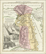
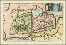
Aegyptus Antiqua by Jan Jansson, dating to approximately 1660 and published in Amsterdam, is a beautiful antique map of ancient Egypt, with an unorthodox orientation where west is positioned at the top. The map's design was influenced by Abraham Ortelius' map that was featured in his Parergon, while this map was included in Jansson's historical atlas.
During the 17th century, Europe experienced a resurgence of interest in the classical world, with scholars, cartographers, and explorers studying ancient texts and artifacts. The Aegyptus Antiqua embodies this intellectual curiosity, offering a glimpse into the geographical understanding of Egypt during antiquity. The map shows the Nile River, major cities, and some topographical features known from classical writings.
Jan Jansson was one of the most prominent cartographers of his time, working closely with other famed cartographers such as the Blaeu family. His inclusion of this map in his historical atlas reflects the high regard in which ancient Egyptian civilization was held during his era.
Jan Janssonius (also known as Johann or Jan Jansson or Janszoon) (1588-1664) was a renowned geographer and publisher of the seventeenth century, when the Dutch dominated map publishing in Europe. Born in Arnhem, Jan was first exposed to the trade via his father, who was also a bookseller and publisher. In 1612, Jan married the daughter of Jodocus Hondius, who was also a prominent mapmaker and seller. Jonssonius’ first maps date from 1616.
In the 1630s, Janssonius worked with his brother-in-law, Henricus Hondius. Their most successful venture was to reissue the Mercator-Hondius atlas. Jodocus Hondius had acquired the plates to the Mercator atlas, first published in 1595, and added 36 additional maps. After Hondius died in 1612, Henricus took over publication; Janssonius joined the venture in 1633. Eventually, the atlas was renamed the Atlas Novus and then the Atlas Major, by which time it had expanded to eleven volumes. Janssonius is also well known for his volume of English county maps, published in 1646.
Janssonius died in Amsterdam in 1664. His son-in-law, Johannes van Waesbergen, took over his business. Eventually, many of Janssonius’ plates were sold to Gerard Valck and Pieter Schenk, who added their names and continued to reissue the maps.