|
||

|

|
|

|
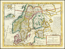
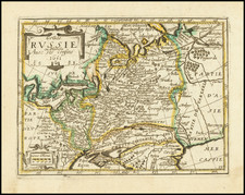
Jan Jansson's map of the Baltic region, first published in Amsterdam around 1640, depicts the regions of Estonia and Latvia. It includes additional notable geographical areas such as the southern tip of Finland, the southeastern tip of Sweden, including Stockholm, and the southern part of the Bothnian Sea.
Jansson's representation is highly detailed, showcasing not only the intricate landforms and political divisions of Estonia and Latvia but extending the perspective to neighboring regions, thereby providing a broader context to Livonia. One of the most striking geographical features included in the map is the Sinus Finnicus, known today as the Gulf of Finland. This body of water is prominently displayed and carefully delineated, highlighting its importance as a major maritime passage of the time.
In addition to the geographical and political details, the map is adorned with a decorative cartouche, designed in line with the artistic conventions of the period, providing not only aesthetic appeal but also grounding the map within its historical and cultural context.
The inclusion of four sailing ships within the map is a noteworthy aspect of the composition. These ships are not mere decorative elements; they symbolize the maritime activities that were central to the economy, trade, and cultural exchange in the depicted regions.
The early part of the century saw Livonia divided between Sweden and the Polish-Lithuanian Commonwealth. Sweden controlled the majority of Estonia and northern parts of Latvia, including Riga, after the Treaty of Altmark in 1629. Under Swedish rule, these areas experienced religious and educational reforms, which brought Lutheran Protestantism and established institutions like the University of Tartu.
In contrast, the southern parts of Livonia remained under Polish-Lithuanian control, maintaining a strong Catholic presence. The division of Livonia between these two powers led to contrasting administrative and cultural practices, reflecting the broader religious and political schisms in Europe during the Thirty Years' War.
The mid-17th century witnessed increased tension and conflict in the region. The Second Northern War, also known as the First or Little Northern War, erupted in 1655, involving Sweden, Poland-Lithuania, Russia, and other powers. The war led to temporary Swedish control over most of Livonia but ended with significant territorial losses for Sweden in the Treaty of Oliva in 1660.
The remainder of the century was characterized by relative stability but growing Russian influence. Tsar Peter I of Russia began to exert pressure on the region, recognizing Livonia's strategic importance in accessing Western Europe. The Great Northern War, which started in 1700, would eventually lead to Russian control over Livonia, although this transition occurred in the early 18th century.
Throughout the 17th century, rulers like Gustavus Adolphus and Charles X Gustav of Sweden, John II Casimir of Poland, and Tsar Peter I of Russia played significant roles in shaping the destiny of Livonia. The interplay between Protestant Sweden, Catholic Poland-Lithuania, and Orthodox Russia, along with their respective ambitions and alliances, created a complex and dynamic political landscape.
Jan Janssonius (also known as Johann or Jan Jansson or Janszoon) (1588-1664) was a renowned geographer and publisher of the seventeenth century, when the Dutch dominated map publishing in Europe. Born in Arnhem, Jan was first exposed to the trade via his father, who was also a bookseller and publisher. In 1612, Jan married the daughter of Jodocus Hondius, who was also a prominent mapmaker and seller. Jonssonius’ first maps date from 1616.
In the 1630s, Janssonius worked with his brother-in-law, Henricus Hondius. Their most successful venture was to reissue the Mercator-Hondius atlas. Jodocus Hondius had acquired the plates to the Mercator atlas, first published in 1595, and added 36 additional maps. After Hondius died in 1612, Henricus took over publication; Janssonius joined the venture in 1633. Eventually, the atlas was renamed the Atlas Novus and then the Atlas Major, by which time it had expanded to eleven volumes. Janssonius is also well known for his volume of English county maps, published in 1646.
Janssonius died in Amsterdam in 1664. His son-in-law, Johannes van Waesbergen, took over his business. Eventually, many of Janssonius’ plates were sold to Gerard Valck and Pieter Schenk, who added their names and continued to reissue the maps.