


|
||

|

|
|

|
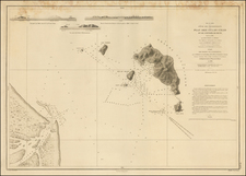
This attractive, elaborate chart of the southern Philippines, published by Robert Laurie and James Whittle in London on May 1, 1794, is an invaluable portrayal of the maritime intricacies of the Southeast Asian archipelago. This chart, with its detailed portrayal of Mindanao, the Sulu Archipelago, and parts of the Celebes Sea, offers a comprehensive view of key maritime routes, critical landforms, and noted harbors in the late 18th century.
The final decades of the 18th century were a pivotal time for European exploration and colonial ambitions in the Asia-Pacific region. As European powers sought to establish and expand their trade routes and territories in Southeast Asia, accurate maritime charts became essential tools.
The map includes "Isle S. Juan from le Gentil's Chart" along with a note "NB. NB.This Isle of St Juan is omitted in several Maps, Chiefly in that of Murillo, and in the Small Chart given to the Officers of the Royal Captain at Surigao." San Juan Island is an enigmatic inclusion on early maps of the Philippines. It corresponds reasonably well to the present-day Siargao Island, which was discovered by the Spanish San Juan de Letrán in 1543. But has received attention as a kind of phantom island on early maps, a point alluded to in the note seen here.
Insets of the Bay of Sooloo and the Harbour of Silla underscore the importance of these areas for maritime activities, both for local traders and foreign merchants. The inclusion of specific routes, such as the "Track of the Warren Hastings," indicates the methodical compilation of firsthand navigational experiences that have contributed to the map's creation.
The chart includes numerous coastal profiles -- topographical illustrations of the islands' elevations. These visual additions provide a tangible sense of the region's geography, bridging the gap between abstract cartographical representations and the actual landscape as experienced by navigators of the era.
Rarity
The chart is very rare on the market. This is the third example we have seen in more than 25 years.
Richard Holmes Laurie (1777-1858) was the son of mezzotint engraver Robert Laurie, who had taken over Robert Sayer's publishing house with James Whittle in 1794. Richard Holmes Laurie joined in a partnership with Whittle when his father retired in 1812. The name of the firm then switched from Laurie & Whittle to Whittle & Laurie. Whittle died in 1818, leaving Richard Holmes to continue publishing alone as R. H. Laurie.
When the Hydrographic Office opened in 1795, it was tasked with creating and producing all the nautical charts for the Royal Navy so as to wean the Navy off dependence on foreign charts. By the 1820s, private publishers were augmenting HO charts and competing with them, including Richard Holmes Laurie. Richard gave up publishing anything except nautical materials by 1830. He also sold charts to Trinity House, the lighthouse and maritime safety fraternity. He died in 1858.
The firm continued to print under the name R.H. Laurie even after 1858. Later, the firm was managed by Laurie’s draughtsman, Alexander George Findlay, and, later, Daniel and William Kettle.
James Whittle (1757-1818) was a British engraver and map printer. Whittle was employed by Robert Sayer (ca. 1725-1794). Together with Robert Laurie (1755?-1836), he took on Sayer’s business when the older man died in 1794. The two traded together as Laurie & Whittle until 1812, when Laurie retired. They had specialized in sea charts and maritime atlases. Whittle then partnered with Laurie’s son, Richard Holmes Laurie, until he died in 1818.
![[ Philippine Islands ] This Pocket Map of Philippine Islands...](https://storage.googleapis.com/raremaps/img/small/94096.jpg)
![[ China Sea / Luzon / Hong Kong / Canton / Formosa ] Bogt Toncqin (VOC - Dutch East India Chart by Its Chief Map Maker in Batavia)](https://storage.googleapis.com/raremaps/img/small/64690.jpg)