


|
||

|

|
|

|
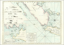
Plan of the Road and City of Batavia on the North Coast of Java Island, published on 12th May 1794 by Laurie & Whittle of 53 Fleet Street, London, is a detailed and historically significant cartographic representation of Batavia, now known as Jakarta, and its surrounding maritime landscape. The map, enhanced by Captain H. Smedley's improvements and corrections to the original by Gerard Van Keulen, offers a comprehensive view of the city and its environs during the late 18th century.
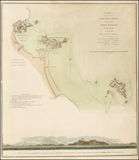
The map features an inset in the lower left, titled The City of Batavia and its District, providing a closer look at the urban layout of Batavia. The main map, meanwhile, extends beyond the city to include a variety of small islands and reefs. Notably, it provides historical notes on the groundings of British and Dutch vessels, offering a glimpse into the maritime history of the region.
One of the key features of the map is the depiction of the fort at Onrust Island, a significant site during the Dutch colonial period. The map also includes other constituent islands of the Thousand Islands, a chain of islands to the north of Jakarta's coast. These features underscore the strategic importance of Batavia and its surrounding waters during the era of European colonial expansion in Southeast Asia.
The year 1794, when the map was published, falls within the Dutch East Indies period, when Batavia served as the administrative and commercial center of the Dutch colonial empire in the East Indies. This map, therefore, serves as a valuable historical document, capturing the geography and urban layout of Batavia at a time when it was a hub of trade and colonial administration.
The chart notes that it includes improvements by Captain Henry Smedley, who seems to have undertaken surveys of the region aboard the Raymond, and whose observations were used to correct a number of Sayer & Bennett charts of the region.
Robert Laurie (ca. 1755-1836) and James Whittle (1757-1818) formed their Fleet Street, London-based firm upon the 1794 death of their employer Robert Sayer, himself one of the dominant print and mapmakers of the last half of the 18th century.
Laurie & Whittle started managing Sayer's business as early as 1787. They took over all managerial duties when Sayer's health flagged in 1792, and they changed the imprint in 1794 upon his death. Sayer left the two a 21-year lease on the shop (at £100 a year) and on Sayer's Bolt Court premises, as well as an option to acquire stock and equipment at a preferential price of £5,000 payable over three years.
Robert Laurie retired from the firm in 1812, and his role was assumed by his son, Richard Holmes Laurie (1777-1858). The younger Laurie worked with James Whittle until the latter died in 1818. After R. H. Laurie died in 1858, Alexander George Findlay, FRGS (1812-1875) purchased the firm from his daughters. The firm continues today under another name, specializing in yachting charts.
Laurie & Whittle were prolific print and map publishers, and throughout their careers, they produced numerous very important and rare works. They carried on Robert Sayer's atlas business and were responsible for editions of The Complete East-India Pilot and The American Atlas.
![Asia Secunda Pars Terrae in Forma Pegasi [Asia in the Form of Pegasus]](https://storage.googleapis.com/raremaps/img/small/94173.jpg)
![Asie No. 110. Partie De Camboge [Vietnam]](https://storage.googleapis.com/raremaps/img/small/0206gh.jpg)