


|
||

|

|
|

|
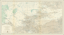
Interesting early 18th Century map of India, Ceylan and the Maldives, extending north to Tibet.
Moll provides a detailed mapping of the Indian subcontinent during the first half of the 18th Century. .
The map provides an overview of the major cities, rivers, and key roads of the time. The road from Conti to Morang, Patna, Agra, Lahor, and Pencab is carefully marked, providing historical insight into the vital trade routes and communication lines of the period.
The map includes detailed depictions of major cities such as Delhi, Agra, and Lahore, which were pivotal centers of power, culture, and trade during the Mogul empire's reign. The rivers, notably the Ganges and the Indus, are clearly outlined, serving as reminders of their crucial role in shaping the region's historical geography and their function as significant trade routes.
The map notably portrays the expanse of the Mogul empire, showcasing its influence and power during this period. This portrayal also points to the political transitions that were to come in the following decades, marked by the decline of the Mogul Empire and the rise of the British East India Company.
Herman Moll (c. 1654-1732) was one of the most important London mapmakers in the first half of the eighteenth century. Moll was probably born in Bremen, Germany, around 1654. He moved to London to escape the Scanian Wars. His earliest work was as an engraver for Moses Pitt on the production of the English Atlas, a failed work which landed Pitt in debtor's prison. Moll also engraved for Sir Jonas Moore, Grenville Collins, John Adair, and the Seller & Price firm. He published his first original maps in the early 1680s and had set up his own shop by the 1690s.
Moll's work quickly helped him become a member of a group which congregated at Jonathan's Coffee House at Number 20 Exchange Alley, Cornhill, where speculators met to trade stock. Moll's circle included the scientist Robert Hooke, the archaeologist William Stuckley, the authors Jonathan Swift and Daniel Defoe, and the intellectually-gifted pirates William Dampier, Woodes Rogers and William Hacke. From these contacts, Moll gained a great deal of privileged information that was included in his maps.
Over the course of his career, he published dozens of geographies, atlases, and histories, not to mention numerous sheet maps. His most famous works are Atlas Geographus, a monthly magazine that ran from 1708 to 1717, and The World Described (1715-54). He also frequently made maps for books, including those of Dampier’s publications and Swift’s Gulliver’s Travels. Moll died in 1732. It is likely that his plates passed to another contemporary, Thomas Bowles, after this death.
![[Puducherry-- Hand Drawn Map] Plan de la Ville de Pondichery. Legende des Rues de la ville blanche et de la ville noire de Pondichery avec les numeros d'ordre correspondant a ceux du plan que Mr. le Gouvernor a approuve le Mai 1856](https://storage.googleapis.com/raremaps/img/small/58607.jpg)
![[ Kashmir ] Vacances au Cachemire](https://storage.googleapis.com/raremaps/img/small/80937.jpg)
![[ India ] Magni Mogolis Imperium](https://storage.googleapis.com/raremaps/img/small/99730.jpg)