|
||

|

|
|

|
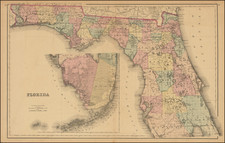
Geologic and Topographic Map of Florida, produced by the United States Geological Survey in 1909 and developed under the supervision of G.C. Matson, F.G. Clapp, and Samuel Sanford, was guided by T. Wayland Vaughan in collaboration with the Florida Geological Survey. This map offers a detailed view of Florida's geological features, presenting a systematic classification from the Quaternary to the Oligocene periods.
The early 20th century saw increased interest in detailed geological mapping to comprehend land formations, potential resources, and historical terrain developments. Florida's geological structure, characterized by its unique limestone foundation, became a focal point of such studies. This map delineates the distinct geologic units present in the state, from the coralline nature of the Key Largo limestone to the sandy shell composition of the Nashua marl. Through its categorizations and annotations, it provides a nuanced understanding of the sequences that underpin the Florida landscape.
Complementing the main map are two insets. One, titled "Section Across the Peninsula of Florida in the Latitude of Daytona and Ocala," gives a cross-sectional representation of the region's subterranean layers. The other, highlighting the "Westward Extension of Florida," covers the portion of the Panhandle not shown in the main image.
This document exemplifies the collaborative efforts between state and federal geological bodies in the early 1900s. The coordination between the Florida State Geological Survey and the United States Geological Survey resulted in this thorough and informative map, marking a significant contribution to the geological literature of the time.
Editions
The Touchton Map Library holds editions of 1909, 1913, 1915, and 1918.