|
||

|

|
|

|
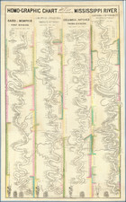
This large wall map, titled Atchafalaya-Pontchartrain Basins of the Alluvial Valley of the Mississippi River, serves as an insightful and detailed representation of the lower Mississippi's geography, specifically highlighting the southern half of the Alluvial Valley. This 1939 edition was prepared under the auspices of the Mississippi River Commission, the Secretary of War, and the Chief of Engineers of the United States Army.
Reduced from detailed surveys conducted by the Mississippi River Commission, the map was devised to provide a comprehensive understanding of the region, emphasizing its unique alluvial features and the intricate network of the Mississippi River. The map also showcases various aspects such as elevations above Mean Gulf Level, timber areas, hard impervious surfaces, roads, earth levees, reservoirs, and other surface improvements, all of which offer invaluable insights into the geographical and man-made features of the region.
The Atchafalaya-Pontchartrain Basins of the Alluvial Valley of the Mississippi River is thus an exemplar of river cartography from the first half of the twentieth century. The map offers an intriguing look into the past, providing insights into how such geographical surveys contributed to our understanding and development of the Alluvial Valley and the wider region.

![Louisiana [inset:] Vicinity of New Orleans](https://storage.googleapis.com/raremaps/img/small/87567.jpg)