


|
||

|

|
|

|
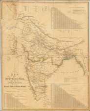
An Early Colonial Map of India
Centered on the Indian subcontinent, the map illustrates the vast holdings of various European powers, with a particular focus on the British territories. The mapped regions include the expansive Mughal Empire, various kingdoms, and states. Crucial elements such as major roads connecting significant cities are meticulously plotted, providing an understanding of the crucial communication lines of the time.
Several noteworthy urban centers, including Delhi (Jehan Abad), Agra (Ekbar Abad), Bombay, Goa, Calcutta, and Pondicherry, are distinctly identified, among numerous other cities. These labels offer a keen insight into the cultural and political landscape of 18th-century India, reflecting the region's complex mesh of indigenous and colonial influences.
In the map's lower right corner, an inset provides an intricate detailing of the River Ganga or Ganges, tracing its path from Hooghly, the southern part of Calcutta, to the Bay of Bengal. This cartographic detail underscores the significance of this riverine system to the region's geography and human activities.
The map is also aesthetically distinctive for its illustrative embellishments. Notably, an illustration of an elephant and trees, as well as a church, are placed below the map, and a decorative scene featuring an elephant is positioned underneath the title cartouche. These decorative elements, while serving to enliven the map's visual appeal, also reflect the prevalent European fascination with the exotic flora, fauna, and architectural elements associated with the Indian subcontinent.
![[ Awadh ] Preliminary Map of Oudh Compiled From The Latest Revenue Surveys, Based On The Great Triangulation](https://storage.googleapis.com/raremaps/img/small/94247.jpg)
![(First State!) [ India ] Tabula Asiae X](https://storage.googleapis.com/raremaps/img/small/94639.jpg)