


|
||

|

|
|

|
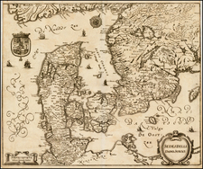
Uplandia, an exceptional map published by the renowned Dutch cartographer Jan Jansson around 1650, displays an impressive representation of Stockholm and its surrounding areas. Jansson brilliantly captures the intricate geography of the region, showcasing the jagged coastline and nearby mountains surrounding the Swedish capital.
An exquisite feature of this map is the beautifully ornate title cartouche that significantly enhances its visual appeal. The maritime ambiance is reinforced with artful depictions of galleons, embodying the naval importance of the region during that era. Furthermore, the map presents a detailed mileage scale placed beneath the regional Upland coat of arms, an emblem of great significance in the area.
Jansson's Uplandia embodies the meticulous skill of its creator and offers a detailed window into the geography of Stockholm and its environs during the mid-17th century. It stands as an intriguing blend of geographical information and artistic flair.
Jan Janssonius (also known as Johann or Jan Jansson or Janszoon) (1588-1664) was a renowned geographer and publisher of the seventeenth century, when the Dutch dominated map publishing in Europe. Born in Arnhem, Jan was first exposed to the trade via his father, who was also a bookseller and publisher. In 1612, Jan married the daughter of Jodocus Hondius, who was also a prominent mapmaker and seller. Jonssonius’ first maps date from 1616.
In the 1630s, Janssonius worked with his brother-in-law, Henricus Hondius. Their most successful venture was to reissue the Mercator-Hondius atlas. Jodocus Hondius had acquired the plates to the Mercator atlas, first published in 1595, and added 36 additional maps. After Hondius died in 1612, Henricus took over publication; Janssonius joined the venture in 1633. Eventually, the atlas was renamed the Atlas Novus and then the Atlas Major, by which time it had expanded to eleven volumes. Janssonius is also well known for his volume of English county maps, published in 1646.
Janssonius died in Amsterdam in 1664. His son-in-law, Johannes van Waesbergen, took over his business. Eventually, many of Janssonius’ plates were sold to Gerard Valck and Pieter Schenk, who added their names and continued to reissue the maps.
![[ Southern Baltic Sea ] De Custen van Schoonen en Swede van Valsterboen tot Christianopolis Bornholm en de Custen van Pomeren van't Eylant Rugen tot Rygs-hooft](https://storage.googleapis.com/raremaps/img/small/67743.jpg)
![[ Nyköpings Chiefdom / Southwestern Sweden ] Charta öfver Nyköpings Höfdingedöme. Utgivfven Af Firherre S. G. Hermelin. Författad af CP Hällström, Premiär Ingeniör, 1804](https://storage.googleapis.com/raremaps/img/small/99082.jpg)