|
||

|

|
|

|
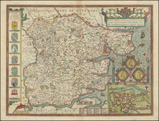
Published around 1610 in Amsterdam, Warwicum, Northhamtonia, Huntingdonia, Cantabrigia, Suffolcia, Oxonium, Buckinghamia, Befordia, Harfordia, Essexia, Berceria, Middlesexia, Southhatonia, Surria, Catiu & Southsexia is a remarkable cartographic document by esteemed mapmakers Jodocus Hondius and Gerhard Mercator. This detailed map of Southwestern England, with distinct color-coding for each county, originates from the esteemed Mercator-Hondius Atlas sive Cosmographia...
Reflecting the handiwork of Hondius and Mercator, the map offers an in-depth geographical representation of Southeastern England. Each county, from Warwickshire to Sussex, is demarcated by unique color hues, establishing clear geographical boundaries while also introducing a visual richness to the map.
In line with the notable attention to detail that characterizes Hondius and Mercator's work, the map presents an intricate array of topographical elements, settlements, and infrastructure. Prominent cities, towns, and villages are marked across the counties, offering a detailed glimpse into the spatial distribution of settlements during the early 17th century.
Moreover, the map displays a comprehensive network of rivers, highlighting the importance of these natural waterways in the region's geography and development.
Warwicum, Northhamtonia, Huntingdonia, Cantabrigia, Suffolcia, Oxonium, Buckinghamia, Befordia, Harfordia, Essexia, Berceria, Middlesexia, Southhatonia, Surria, Catiu & Southsexia, therefore, provides not only a compelling depiction of southeastern England in the early 17th century but also a testament to the prodigious cartographic accomplishments of Jodocus Hondius and Gerhard Mercator.
Jodocus Hondius the Elder (1563-1612), or Joost de Hondt, was one of the most prominent geographers and engravers of his time. His work did much to establish Amsterdam as the center of cartographic publishing in the seventeenth century. Born in Wakken but raised in Ghent, the young Jodocus worked as an engraver, instrument maker, and globe maker.
Hondius moved to London in 1584, fleeing religious persecution in Flanders. There, he worked for Richard Hakluyt and Edward Wright, among others. Hondius also engraved the globe gores for Emery Molyneux’s pair of globes in 1592; Wright plotted the coastlines. His engraving and nautical painting skills introduced him to an elite group of geographic knowledge seekers and producers, including the navigators Drake, Thomas Cavendish, and Walter Raleigh, as well as engravers like Theodor De Bry and Augustine Ryther. This network gave Hondius access to manuscript charts and descriptions which he then translated into engraved maps.
In 1593 Hondius returned to Amsterdam, where he lived for the rest of his life. Hondius worked in partnership with Cornelis Claesz, a publisher, and maintained his ties to contacts in Europe and England. For example, from 1605 to 1610, Hondius engraved the plates for John Speed’s Theatre of the Empire of Great Britaine.
One of Hondius’ most successful commercial ventures was the reprinting of Mercator’s atlas. When he acquired the Mercator plates, he added 36 maps, many engraved by him, and released the atlas under Mercator’s name, helping to solidify Mercator’s reputation posthumously. Hondius died in 1612, at only 48 years of age, after which time his son of the same name and another son, Henricus, took over the business, including the reissuing of the Mercator atlas. After 1633, Hondius the Elder’s son-in-law, Johannes Janssonius, was also listed as a co-publisher for the atlas.
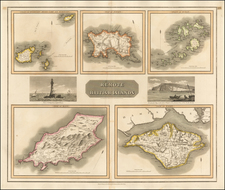
![Channel Islands [Guernsey and Jersey]](https://storage.googleapis.com/raremaps/img/small/46638.jpg)