|
||

|

|
|

|
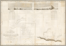
Scottish National Antarctic Expedition Map: Tracing the Voyage of the "Scotia"
The "Scottish National Antarctic Expedition Map Showing the Track of the 'Scotia' 1903-1904" is a detailed cartographic representation of Scotia's voyage of exploration in 1903 and 1904, which resulted in the expeditions reaching the southern most point on Coats Land in 1904.
Under the leadership of Scottish scientist William Speirs Bruce, the Scottish National Antarctic Expedition (1902-1904) set out with the ship "Scotia". Sailing south from the island of Troon, "Scotia" journeyed into the Weddell Sea, establishing a meteorological station on Laurie Island. This marked the beginning of the continuous meteorological observations in the Antarctic, a practice which continues to this day. The crew also discovered new land east of the Weddell Sea, which Bruce named Coats Land after the expedition's main sponsors.
Amidst various challenges posed by the icy waters and treacherous weather conditions, the team conducted extensive oceanographic, botanical, and zoological studies. The expedition's return not only added vast knowledge to Antarctic science but also solidified Scotland's position in the annals of polar exploration.
The the intricate paths taken by various explorers in the icy terrains of the Antarctic waters. Through carefully plotted lines and markers, it chronicles the exploratory endeavors of a list of esteemed explorers, while particularly highlighting the journey of the "Scotia".
Explorers and Their Expeditions: A Brief Overview
The tracks of the Scotia are super-imposed upon the tracks of numerous other explorers.
-
James Weddell (1822-1824): An English seafarer, Weddell voyaged into the Southern Ocean, discovering what is now known as the Weddell Sea, which remains one of the southernmost seas on Earth.
-
William Smith (1819): Smith, a British merchant, discovered the South Shetland Islands, marking the first discovery of land south of 60° south latitude.
-
James Clark Ross (1839-1843): Leading the British Antarctic Expedition, Ross and his crew navigated through the Ross Sea, discovering Ross Island and the Victoria Land region.
-
Jules Dumont d'Urville (1837-1840): The French explorer's Antarctic expedition led to the discovery of parts of the Antarctic continent, notably naming the Adélie Land after his wife.
-
John Biscoe (1830-1832): An English explorer, Biscoe circumnavigated the Antarctic continent, discovering the Biscoe Islands and parts of the Antarctic mainland.
-
Fabian von Bellingshausen (1819-1821): A Russian explorer, Bellingshausen is recognized for leading the first expedition that sighted the Antarctic mainland.
-
James Cook (1772-1775): While Cook didn't see the Antarctic mainland, his southern voyage reached the Antarctic Circle, making significant contributions to the world's knowledge of the region.
-
Karl-Anton Moore (1820-1821): Moore led a British sealing expedition, where he made multiple significant sightings, especially of the South Orkney Islands.
-
Henry Foster (1828-1831): Foster, on his voyages aboard the "Chanticleer", undertook critical scientific observations in the South Atlantic, including around the South Shetland Islands.
-
William Hudson (1839) In 1839, Lt. William Hudson, part of the Wilkes Expedition, played a pivotal role in the exploration south and west of Australia, aiding in the discovery of the Antarctic coast.
-
Adrien de Gerlache (1897-99): In 1897, Belgian explorer Adrien de Gerlache led the "Belgica" expedition to the Antarctic Peninsula, discovering the Gerlache Strait and enduring an unplanned winter trapped in pack ice, marking the first crew to winter south of the Antarctic Circle.
![[ Karte des Nordens von America, Zur Beurtheilung der Wahrscheinlichkeit einer nord=westlichen Durchfhart, gezeichnet von G. Forster, 1791.]](https://storage.googleapis.com/raremaps/img/small/41816dm.jpg)